 by Bill Straka
Table of Contents
Background
While it is always best to avoid getting lost or injured in the first place, an increasing number of people are heading into remote backcountry areas, some lacking in navigational and survival skills. The result is an increasing number of incidents requiring the rapid summoning of help. At the same time, the proliferation of cell phones and GPS receivers has increased dependence on electronic devices to locate lost and injured persons.
While 911 emergency systems can summon aid in urban areas, typically with a 5-minute response time, an expectation of rapid response in non-urban areas has developed. Thus the concept of a device similar to aircraft Emergency Locator Beacons (ELT), marine emergency beacons (EPIRB/Emergency Position Indication Radio Beacon), and skiers’ avalanche beacons has given rise to several types of pocket-sized personal locator and tracking devices.
The traditional locator device is a simple transmitter that is activated in an emergency situation such as a hard impact (aircraft) or immersion in salt water (marine beacons), with the option of manually activating it. In the case of avalanche beacons, the beacon is turned on at the start of a tour and left on continuously in case the wearer is caught in an avalanche. In the past, a transmission did not include any identifying or location information, and had to be found by a relatively complex search procedure. Now, many EPIRB’s for aircraft, marine, and backcountry use transmit an identification code and are located by reception by satellites. For many applications, coded EPIRB’s are required, and must be registered.
There are three types of emergency location devices available for the backcountry traveler.
TracMe
The simplest device is similar to the basic ELT or avalanche beacon, in that it transmits a simple signal that must be located by a grid search procedure. The TracMe is an example of this. It is activated by pulling the bottom off. It then transmits a signal on FRS Channel 1. The searcher has to know that the person is missing to begin the search and must have an FRS radio. The search consists of proceeding in the direction the missing person is thought to have taken, while listening to the FRS radio. The signal can be received if you are on line of sight up to 2 to 5 miles, depending on the terrain. Once the signal is acquired, you continue in the same direction until the signal peaks and starts to fade. You then turn at right angles at the peak signal point and find the next peak signal point. This type of grid search is the simplest for an untrained searcher, but can be improved by someone familiar with avalanche search procedures.
The strength of the TracMe type of device is its simplicity and low cost. A young child can be trained in its use and can carry it with him or her. If she discovers she is lost, she can activate the unit and stay in one place until found. Youth organizations can equip everyone in the group with a unit, with the leaders having FRS radios to conduct a search. The weakness is that you must know that a person is missing, their general location, and that they have a TracMe.
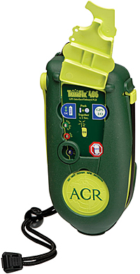
Personal Locator Beacon (PLB)
An example of the most sophisticated Personal Locator Beacon (PLB) is the ACR TerraFix 406. Like the marine EPIRB, it transmits on 406MHz, must be registered, and is received by the COSPAR-SARSAT satellite system. It includes a GPS-derived position in its transmission, so the satellite system can get a much more accurate location than the simple triangulation used for EPIRB’s without an included GPS receiver. It is, however, quite expensive, costing typically $600-$700 (though sometimes on sale for as little as $400). Like all PLB’s, it must be activated manually.
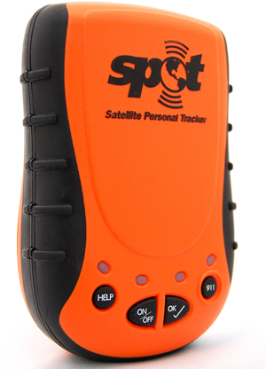
SPOT
Recently, a much less expensive emergency beacon, known as SPOT (Satellite POsitioning and Tracking), has become available. Like the ACR TerraFix, SPOT includes a GPS receiver. However, instead of using COSPAR-SARSAT, SPOT (a subsidiary of Globalstar) transmits its messages via the digital service of the Globalstar satellite phone system.
Basic Features of SPOT
SPOT has several attractive features. First is the price ($170 plus an annual subscription, depending on how much message capability you want). Second is that you have several message types you can send out: OK, Help, and 911.
OK and Help
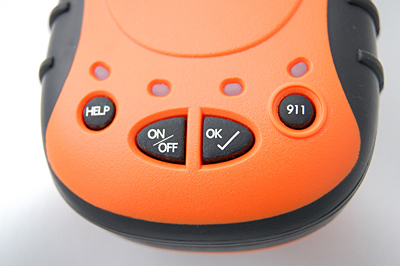
The OK and Help messages are sent to a group of up to five people you designate for each type at their email or cell phone text address. The 911 message is sent to an international search and rescue coordination agency, which then attempts a contact with your designated primary contact to confirm your registered information, then notifies the main search and rescue agency nearest your location as given by the SPOT 911 message.
The OK and Help messages are pre-programmed by the user on the SPOT website before you head into the field, along with your list of contacts for each of the two message types. For example, your OK message might be “I’m OK, but running late.” The OK message is repeated three times during a 20-minute period, to ensure that it is transmitted via the Globalstar network.
The Help message might be “I’m stranded at this location and need assistance.” These messages are transmitted at 5-minute intervals, along with the time and GPS-derived location. This information is relayed to your five Help contacts, along with a link to GoogleEarth that will display your location on a satellite image or map. This allows notification at a level that does not require a full-scale search-and-rescue effort (see the GoogleEarth image, Figure 9, below).
Track
Another type of information that can be transmitted to a designated group is the Track information. This is a simple time and location message, transmitted every 10 minutes, that is stored on the SPOT website for up to 30 days. It is accessed by someone you have supplied with your username and password, or can be shared by means of a Share message, sent to a list of recipients, that allows them to click on a link that allows display of the Track locations on a GoogleEarth map.
911
Unlike the traditional PLB, the SPOT 911 message does not activate the COSPAR-SARSAT network. Rather, the message is relayed via Globalstar to the GEOS International Emergency Response Center, repeated at 5-minute intervals until cancelled or the battery runs dead. This message includes your identification, the time of the message, and, if a GPS-derived position is available, the position. When GEOS receives the message, they attempt to contact your primary contacts to verify the information on file. GEOS then notifies the search and rescue (SAR) agency in the area of the location. If SPOT does not have a GPS lock, GEOS continues monitoring the signal and attempting to contact your primary contacts.
Field Testing and Evaluation
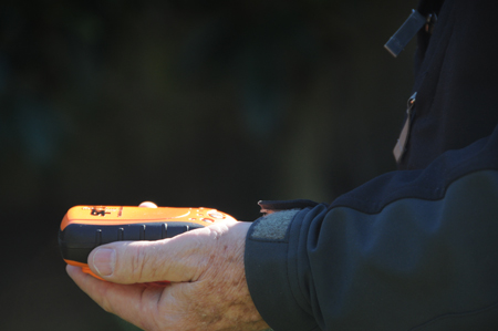
Figure 4. The author tests his SPOT device. For the best message transfer it is important to hold the SPOT horizontally. (Credit: Bill Straka)
Overall, SPOT is an excellent concept. It provides a relatively inexpensive means of summoning help in an emergency, providing approximate tracks, and sending brief status messages, while in remote locations. Operation of the device is simple, a very desirable feature for an emergency signaling device.
During my testing of SPOT over a six-month period, I put it through tests in a few simple and a number of more difficult situations. Because SPOT uses a GPS-derived position for each of the message types, I included the very trying canyon and canopy situations, including the steep canyons and redwood forests in the Santa Cruz mountains and mountainous terrain in the Sierra Nevada. Tracking tests were performed during hikes on established trails and off-trail, and on bicycle. Help messages were generated in the full range of locations and while in a snow cave. The 911 function was not tested, but is similar enough to the Help function that the results should be representative.
In the case of Help messages, I allowed the SPOT to run for an hour or two at a fixed location, then averaged the locations. Individual positions varied up to 150 feet from one another. This is due in part to the inherent random variations in positions derived from the GPS data and in part due to the “quantization” of the SPOT reports (SPOT reports longitude and latitude in decimal degrees to 4 places (0.0001 degrees), or approximately on a grid with a 36 foot spacing.
Error sources for GPS-derived positions include errors in the clocks in each satellite and in the receiver, atmospheric effects in the ionosphere and troposphere through which the signals for each satellite must pass, drift of the orbit from the most recently updated ephemeris for each satellite, and other factors. When the Help positions for durations of an hour or more were averaged, the derived location was always within 5 feet of the actual location derived from topographic maps and from positions obtained from commercial GPS receivers (including one case where a survey-grade GPS position was obtained).
The top-level conclusion is that, as an emergency locator, SPOT is adequate for most probable users. There are some limitations that can be worked around if the user will make the effort to become familiar with SPOT in benign situations before venturing into a higher risk situation. Details will be given in the following discussion.
Basic Operations
Setting up and using the SPOT is very simple out of the box, perhaps deceptively so, since getting a really useful emergency message through requires a little understanding of how the system works, from the GPS-based part of SPOT through the relaying of the messages via Globalstar to your team or GEOS. This same caution about making SPOT fully reliable applies to any emergency locator. However, the skimpy user manual and the website both are less informative than desirable, although more information has been added to the website over time.
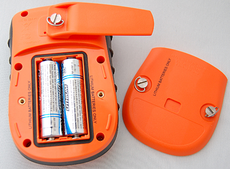
Figure 5. Step one of SPOT’s easy set-up: insert batteries.
All that is necessary to get SPOT ready for use is to remove it from the box, insert the batteries (preferably lithium-iron AA’s — alkaline batteries have a much shorter life), and setting up your profile on the SPOT website. Your profile consists of creating a message for the OK and Help functions, entering the contact information for up to five team members each for the OK and Help functions (email address or text-messaging address), and providing certain information for the 911 function. You should review and update your information for each trip, as you should do anyway in providing information to your contacts on your itinerary for each trip.
Once at the trailhead, the unit is turned on by holding the power button down for a couple seconds. An OK signal is sent by pressing the OK button and holding it for a couple of seconds. The OK and power LEDs will blink simultaneously, indicating that a 3D fix has been obtained. The unit will attempt three times during a 20-minute period to send a signal through the Globalstar satellites. When the signal is being sent, the OK light will glow steadily for a few seconds. Because relaying the signal is dependent on a Globalstar satellite being in the right position, it is best to keep the unit oriented properly in a location with a clear view of the sky for the full 20 minutes.
During my tests, I found that the message usually got through within 10 minutes if I was in a favorable location, but often did not get through if I turned the unit off in less than 10 minutes, if I were in less favorable locations or was moving, or was not careful to keep the unit properly oriented. If the unit does not have a 3D lock, the message that is transmitted includes a comment “No GPS Fix” (see example below). This message may still get through, however.
It is important to note, that while SPOT indicates that OK, Help, and 911 messages have been transmitted, there is no indication that the message has or has not been received. To be fair, the same is true of most, if not all, ELT, EPIRB, and PLB units for the non-military user.
To track your position, the OK button is held down until the OK LED shuts off, indicating that the Track mode has been entered. The power and OK lights then will blink simultaneously every few seconds as long as a 3D fix on the GPS satellites is held, but will blink at different rates when lock is lost. In the Track mode, your position is sent to your user file on the SPOT website, and to those people for whom you have created a Share notification (more about Share later).
If a situation arises in which you need to call for help, you can send a message with either the Help or 911 buttons, depending on the seriousness of the situation and/or your arrangements for a backup team. In either case, with the SPOT turned on, hold the Help or 911 button down for about 5 seconds to initiate the request. With the Help button, the message sent is the one you preprogrammed on your SPOT web page, with an attempt to send every 5 minutes, continuously until the battery runs down. This message goes to the Help team you entered before leaving on your outing.
The 911 message is sent to the GEOS international site, which attempts first to contact the primary contact you supplied. This helps to confirm that the message is real and not a false alarm (two friends who have used SPOT have accidentally triggered the 911 message during an outing). GEOS then contacts the search and rescue agency covering the area in which the signal originated. Both the Help and 911 messages can be cancelled.
The following are some typical messages that get sent to your team. Although the dates of the messages may be fairly old by the time you read this, I believe you will be able to see the GoogleEarth display if you enter the URL in your browser. Note that the messages contain a title, identifying the type of message, the serial number of the SPOT unit, the latitude and longitude (to 4 places in decimal degrees, or approximately 36 feet), a “Nearest Location” and distance to the location, the time of the transmission in Universal Time (not the local time at the location), and the URL to see the GoogleEarth display.
The “Nearest Location” often comes up as “not known”, even when in a city or other well-defined location. In a number of cases, the named location is fairly obscure or may be a significant distance away. It would seem to be of minor importance, since the lat/lon position is given to about 36 feet, a much more useful piece of information when searching for someone who is lost, especially since you can see the map and satellite image just by clicking on the URL.
Several GoogleEarth satellite images and maps from National Geographic’s Topo! with locations from SPOT tests and tracks obtained with a Garmin 60CSx are shown below.
Figure 6. Donner Pass Area
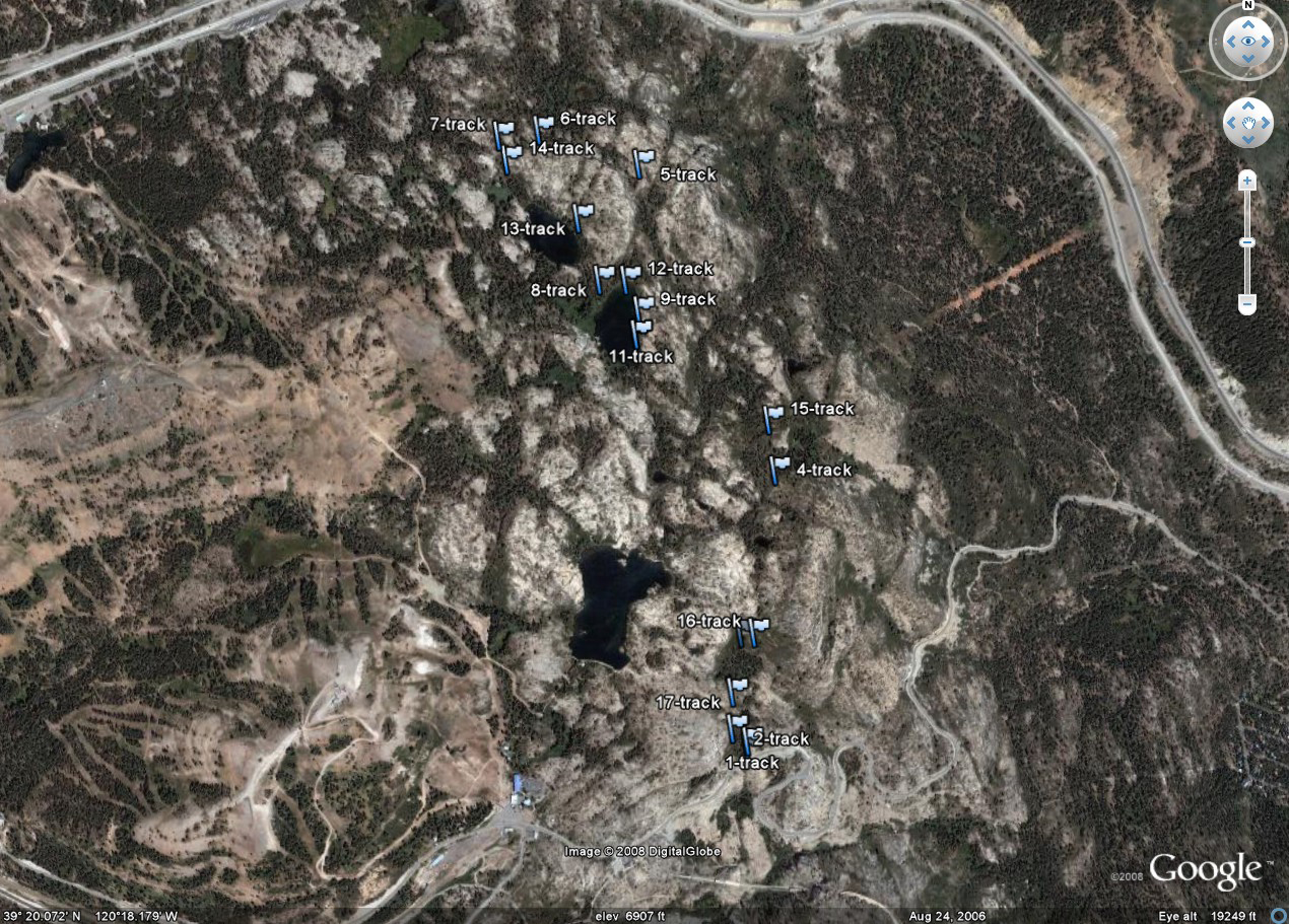
Figure 6 shows the series of Track points generated during a hike along the Pacific Crest Trail, going from Donner Pass north to Flora and Azalia Lakes and returning, as shown on a GoogleEarth satellite image. Note that the spacing between points, which are numbered in time sequence, is not uniform. This is due to dropouts in SPOT holding fixes on the GPS satellites and links to Globalstar under tree canopy and “canyon” effects. Also, since the nominal spacing of Track points is 10 minutes, the trail distance between points at a 3 mile per hour hiking rate is about one half mile. The actual spacing will vary with hiking speed, as well as the loss of satellite contact. Thus, detail of the actual path taken is lost.
Figure 7. Mission Peak, comparing GPS track with SPOT Track points
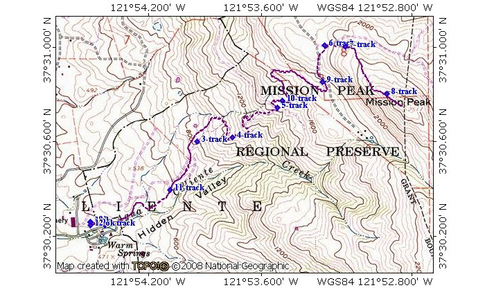
Figure 7 compares a series of SPOT Track points (blue diamonds) collected during a hike up Mission Peak, in the San Francisco Bay Area, to a track file (purple dashed line) recorded with a typical consumer GPS receiver, a Garmin 60CSx. Again, the track points are numbered in time sequence. Some Track points are not on the Garmin track, due in part to the precision of the SPOT being approximately 36 feet, in part because of the inherent error budget of the Global Positioning System, and in part due to terrain effects (“canyon” effects) on the steep hillsides.
Figure 8. OK Message, Windy Hill Open Space Preserve
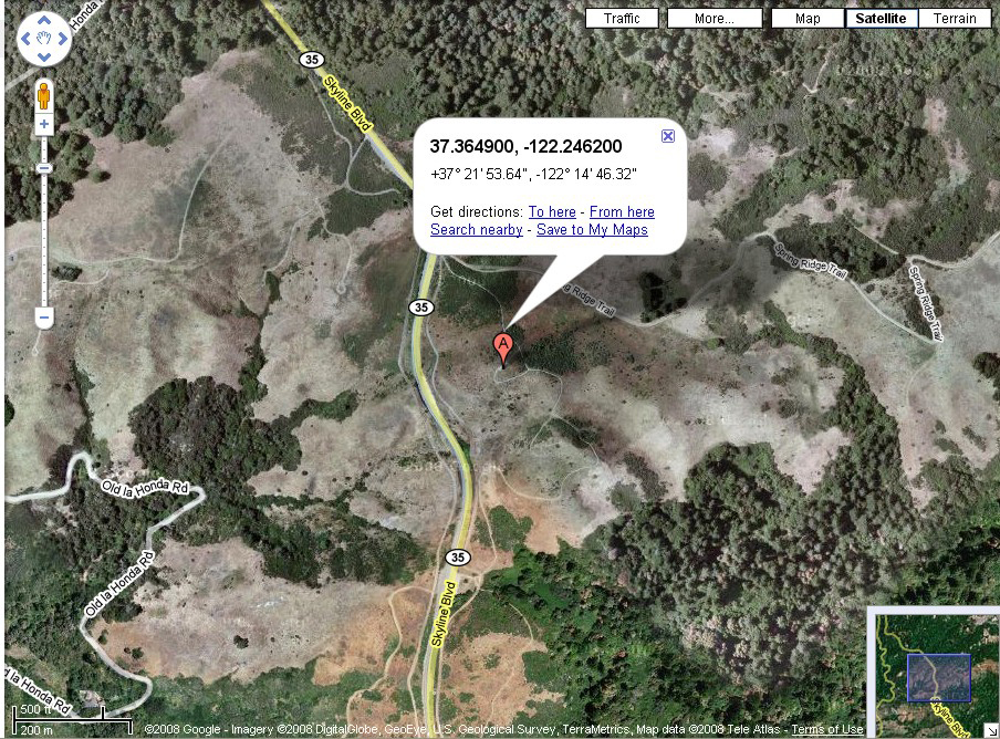
Figure 8 is a GoogleEarth satellite image produced from an OK message. The message used for the image is shown below. When your team members receive an OK or Help message, they can view the image by entering the URL contained in the last line of the message block into most web browsers. The location in this case is Windy Hill, near Skyline Drive on the San Francisco Peninsula.
OK Message
Bill S SPOT test. I'm here.
ESN:0-7361118
Latitude:37.3649
Longitude:-122.2462
Nearest Location:not known
Distance:not known
Time:08/24/2008 18:04:07 (GMT)
http://maps.google.com/maps?f=q&hl=en&geocode=&q=37.3649,-122.2462&ie=UTF8&z=12&om=1
Figure 9. SPOT Help message from inside snow cave
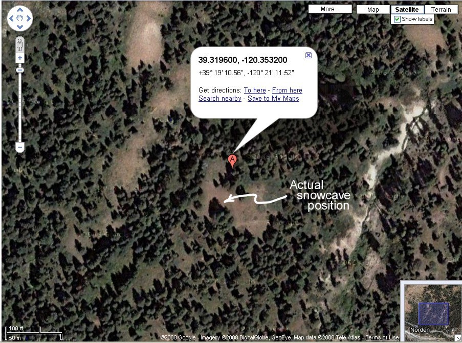
The following Help and Help Cancel messages were generated from inside a snow cave at the location marked in Figure 9 above as “Actual snowcave position.” The position given by SPOT is about 95 feet from the snow cave. GoogleEarth images are in general from snow-free days. Displacement is due to a combination of canyon and canopy effects, plus passage through the roof and walls of the cave. Note, however, that getting within 100 feet is far better accuracy than a search and rescue team is normally provided.
Help Message
This is a HELP message from Bill Straka. Testing only.
ESN:0-7361118
Latitude:39.3196
Longitude:-120.3532
Nearest Location:not known
Distance:not known
Time:03/08/2008 00:31:56 (GMT)
http://maps.google.com/maps?f=q&hl=en&geocode=&q=39.3196,-120.3532&ie=UTF8&z=12&om=1
Help Cancel Message
The help message has been cancelled
ESN:0-7361118
Latitude:No GPS fix
Longitude:No GPS fix
Nearest Location: not known
Distance: not known
Time:03/08/2008 00:38:40 (GMT)
Conclusions
As stated earlier, SPOT serves a very useful function as an emergency location device at a very reasonable price. Keeping the price down led to several compromises in the first generation of SPOT. The biggest compromise was the decision to use a combined GPS receiving and Globalstar transmitting antenna, combined in a flat plate (patch) antenna design. This combination has degraded sensitivity compared to having dedicated separate GPS and satellite communication antennas, compared to current consumer GPSR’s. This results in a significant sensitivity to orientation and to canyon and canopy effects.
The combined antenna also is weaker in getting signals through to the Globalstar satellites than a dedicated separate antenna would be. The GPS chipset was chosen for low power consumption, hence long battery life. This chipset is also less sensitive than chipsets introduced by many companies in the past couple of years.
In practice, these compromises result in skipped updates in Track messages and times when OK and Help messages do not get through. In some cases, I observed gaps of more than 30 minutes, up to over an hour in Track message sequences. This was particularly true when bicycling or hiking under redwoods, but showed up under other conifers as well. Individual positions were sometimes off by 150 feet or more, although leaving the unit stationary for extended periods (such as would normally be the case when sending genuine Help or 911 messages) allows averaging the reported positions and getting positions accurate to a few feet.
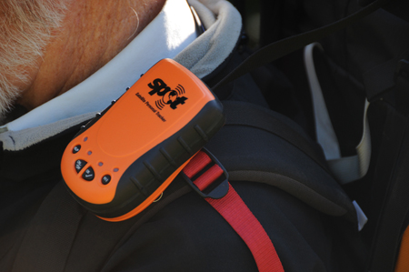
Figure 10. SPOT can be worn horizontally on a pack’s shoulder strap. (Credit: Bill Straka)
Users of the present generation can greatly improve the message transfer success rate by making sure that the SPOT is held horizontal with the SPOT logo facing directly vertically. The inclusion of a belt clip encourages users to clip the unit to the belt or a pack strap in a vertical position. If your pack has a means of clipping the SPOT horizontally on the top or if you can tape SPOT in place in a horizontal orientation (but do not use a metallized tape, such as many versions of duct tape), message transfer and GPS reception will be enhanced. As I determined this during my tests, my success rate at getting a higher percentage of Track positions, and OK and Help messages through the system improved greatly. Further, when sending OK and Help messages, I found that making an effort to get into an open area and to keep the SPOT positioned correctly for 15 to 20 minutes also enhanced the success rate.
It is important to remember that the speed of getting messages through and any actions taken as a result are dependent on the messages being monitored. SPOT’s 911 messages are continuously monitored by GEOS, and the response time is very timely for rescues in remote areas. However, OK and Help messages are sent either as email to your team members’ email system or as a text message to their cell phones. These two message types are intended for less urgent contacts. If your team members’ cell phones are turned off or if they only check their email once a day, any needed action could be long delayed. Some friends who participate in adventure races make sure that their backup team is continuously monitoring their progress.
SPOT has been in the field for more than a year. The real proof is rescues. SPOT is credited with more than 50 rescues. One unsuccessful rescue generated a lot of overly sensational press coverage. However, the 911 signal was received during a significant blizzard in the Sierra, which prevented the search and rescue group from being able to respond quickly. The body recovery was affected before the storm had completely cleared, nonetheless. The autopsy showed that the victim had probably died of hypothermia within hours of the signal being received.
There have been several false alarms, due to the 911 button being pushed accidentally. Two of these involved friends of mine, one during an adventure race and the other on Denali. The adventure race incident involved the 911 button actually being pushed by mistake. This was cancelled when the racer’s primary contact was reached at a checkpoint, at about the same time as she had passed the checkpoint.
The Denali alarm occurred because the unit was in the top pocket of the pack of one of the two in the party and was set down against a rock during a rest stop. The 911 button does have a raised ring around it. I have found in various intentionally trying scenarios that it is indeed possible to accidentally activate the unit (the 911 function was disabled in my test unit intentionally, but the other buttons are sufficiently similar). The SPOT developers are aware of this problem and are addressing it.
In discussions with the developer of SPOT, I learned that they are addressing the issues I mentioned above. In some cases, there have been significant technical advances that address the normal issues with the first generation of any device (as there are in all electronic devices, even in later generations). Other issues concerning the user interface are being addressed also. Hopefully, Trailspace will be able to test the next generation SPOT in the near future. We will update this review when the new version becomes available to us.
Some readers might infer that SPOT has too many problems in its present state. On the contrary, if the user is aware of and takes into account the basic limitations of the Global Positioning System and satellite communications systems, and indeed of all electronic positioning and communications systems, SPOT can be literally a life saver, and has been already. SPOT, like all GPS-based and satellite-communications-based systems is undergoing rapid development. In my discussions with the company, they are taking their mission of making an affordable emergency location device very seriously.
However, no matter how good and how inexpensive personal emergency location devices become, and no matter how rapidly emergency responders can get to the site of an incident, it remains the responsibility of each individual going into the outdoors to be properly equipped, properly trained, and to avoid accidents and incidents. There is risk in everything in life, and no electronic widget is going to completely remove that risk or guarantee life and limb.


