Garmin GPSMap 62st
The GPSMap 62st has been discontinued. If you're looking for something new, check out the best handheld gps receivers for 2024.


 Reviewed by
Andrew Stanner
+358
 April 27, 2016 (original Mar 24, 2016)
Great unit, accurate, reliable and robust, but loses a star because of the BaseCamp software. This GPS can get a signal in many places where other GPS units fail.
Pros
- Push buttons
- Rugged hardware / IPX7 waterproof
- GPS reception / antenna
- Barometric altimeter
- Screen visibility in sunlight
- Accessories
- 20-hour battery life
- Digital compass
Cons
- Screen pixels (160x240)
- Weighs more than most (221g with batteries)
- User manual / online help
- BaseCamp software
- Limits to how many Geocaches can be stored
This unit is quite old, released in August 2010 (five years ago) but sold up until 2016. It has (just) been superseded by the new 64-series of models.
It has been a long time since I have intensively used a GPS. I did engineering at Uni and did two years of Surveying. Back then GPS units were the size of suitcases. Almost 20 years ago in the Army one of my projects was the Army's Y2K project for the GPS system. The whole satellite system was not Y2K compliant and I recall that it cost a lot. GPS units were not consumer devices. Having not owned a GPS (other than my phone) for almost two decades I did a lot of research before buying this one.
Top-end GPS units are very expensive so buying a second-hand unit is very appealing. GPS units don't become obsolete in a year or two - they are not like your phone. Historically Garmin has released major new models about every five years so this old 62st still has a lot of life left in it. One reviewer who sounded knowledgeable also pointed out that it often takes Garmin a year to nail the firmware. The firmware appears to have improved a lot over the past five years and is now very stable.
On a value-for-money basis this unit scores very well!
Prior reviews
A lot of reviews have been done. I was heavily influenced by the favourable review done by The Outdoor Gear Lab / Chris McNamara and Max Neale in May 2013 for the 62sc which is almost identical apart from the addition of a camera. They gave the 62sc model a very good rating and made it their "top pick". Having owned it for a little while now a lot of their comments and observations make sense to me.
There are also very good reviews on gpstracklog.com and there is a hugely detailed 3-part review on freegeographytools.com. Both of these were done soon after the unit was first released back in August 2010. The firmware has been improved a lot since then.
I bought mine second hand and it was almost new. There are still plenty being sold new in shops.
Why this is so good
The Outdoor Gear Lab said that "it was the most accurate and most reliable GPS unit we've tested". They were really effusive about accuracy and reliability. In particular they said:
- The reception is so good that it will work in canyons.
- The buttons are great particularly in cold weather, snow or rain. It took me a few days of serious usage to learn my around the keypad but once I got there it sort of makes sense. Buttons work in the rain, touch screens may not.
- Speed to get a location is the fastest of any unit they had tested and I am surprised how quickly it turns on and locates. Much faster than my phone. I believe the reviews and reports by others.
- Rugged, waterproof and has a battery life of 20 hours which is about right.
These were all important factors for me and this is all true. This is a well thought out unit and in the field it performs very well. Turn it on and you can get a fix very quickly.
Reception
Reception is excellent and far exceeds any mobile phone and probably just about any other hand-held GPS unit. There are lots of technical reasons for this. GPS reception is driven by many factors including:
- Antenna: The Garmin "quad helix antenna" (whatever that is) that sticks out the top. Pretty well all the reviewers agree that the external antenna is a good feature and increases sensitivity and reception over units that have an internal antenna. Much better than the tiny patch that is used in most mobile phones.
- Channels: This unit has 12 channels which is close to optimum for a GPS unit. Typically, there are only 10-12 visible satellites in the constellation of anywhere between 24-33 satellites. Some modern GPS units do have more channels, the benefit is that with a few extra "spare" channels the unit will "listen" for new satellites and will lock-on as soon as they appear over the horizon. But the difference is very marginal.
- Processor / Chipset: Garmin used the STMicroelectronics Cartesio chipset in this unit.
- Other factors include the sensitivity of the receiver, the Garmin WAAS-enabled GPS receiver, the included Garmin HotFix® satellite prediction software and shielding of key receiver circuits etc.
I have found reception to be outstanding and it just works in places where the phone and other GPS units fail. I am often able to turn it on, and get a useable location within 15 seconds.
All GPS units are not made equal. This unit has an excellent antenna, 12 channels and lots of other smarts which is why it works so much better than most GPS units.
Comparisons with the other Garmin GPSMAP 62 series units
There are five models in this Garmin series:
- Garmin GPSMAP 62 (1.7GB base model, no microSD card)
- Garmin GPSMAP 62s (1.7GB compass)
- Garmin GPSMAP 62st (3.5GB, compass + pre-loaded 100k Topo mapping) *(this review)*
- Garmin GPSMAP 62sc (3.5GB, compass + camera)
- Garmin GPSMAP 62stc (3.5GB, compass + pre-loaded 100k Topo mapping + camera)
The new series, the 64 series has similar features. This model is mid-way through the $cost range, I cannot see myself using the camera. I am quite happy with my choice.
Price
The cheapest I could find one in Australia was at Ryda at $329, but it looks like they have now sold their last one and have dropped it from their website in the last month or so. There are still plenty of shops in the US trying to sell them new for over USD $400 but CNET says the usual range is USD239.95 to USD349.95. The new(er) model, the 64st is selling on Amazon for USD$ 299 new or (73 used) from $259. I bought this second-hand for AUD$220 but there are not many for sale in Australia.
Second-hand, this is a great unit and scores well for value-for-money! I couldn't justify spending $468 on the new model which is the Garmin GPSMAP 64ST which only adds more memory, BlueTooth, and GLONASS.
The option to add Garmin TOPO maps for almost another $200 is totally out of the question for me.
Screen
The screen is tiny but functional. It is quite good in the sun (without sunglasses) and is quite readable. It is a TFT display with 160 x 240 pixel resolution which is not a lot. It looks like this. I read a review where the guy said it worked really well on his mountain bike. I am going to try that.
Functionally, most GPS units are quite similar, and even if the screen was larger it would not make a lot of difference. Fundamentally a GPS unit is designed to tell you where you are. They are pretty hopeless for route planning which is really difficult on any device with small screen real-estate. And if you want to know "what mountain is that over there...." then you will really struggle and at that point you need to revert to a map. GPS units are a long way off replacing paper. I would really strongly advise against going digital only.
Setup
It took me days (quite a few) to learn how to use this unit. I understand that all Garmin units have a lot in common and once you learn how to use one, then each new unit is a much easier learning curve. But have no doubt that it is a complex user interface and will take considerable effort to learn. I have years of GPS / software / UI experience and I really struggled to work out how some functions work.
There are a lot of poor reviews on the internet and before I sat down to write this review I read quite a lot of them. In the vast majority of cases I deduced that low scores were given by people who did not invest the many days of effort to learn how to use the unit. I am not quite sure how Garmin will solve that problem in the years ahead but solve it they must. Usability has not been a focus for Garmin and that must change. I suspect they have been putting much of their effort recently into their watch.
But on a positive note, once you have been through the tedious setup and learning process it is quite user friendly. Put in charged batteries, turn it on and it is easy to use.
I demonstrated it to a friend this afternoon, that involved:
- Turning it on
- Finding a pre-loaded waypoint at the start point of our next trip
- Pulling up the map for that waypoint
- Turning GPS search off (because we were indoors)
- Showing my friend the latest OSM map of the intended route
Seriously it took me about four days of solid effort to become that competent in the use of the unit, load maps and waypoints etc!
Software
There is a lot of Garmin software, in the process of using this GPS I have encountered four pieces of software.
Garmin Custom Express software
This appears to be almost single purpose software, designed to update the firmware on the unit. It did its job well without any problems.
Garmin USB Drivers
These were easily installed. It took me a while to realise I needed them though. A quick-start guide would have helped by pointing this out. Or perhaps a mention in the owner's manual.
Garmin MapInstall
Single purpose software designed to install maps on the unit. No problems after I got the driver issue sorted.
Garmin BaseCamp software (ver. 4.6.2)
Not so good. I really gave it a good crack but struggled with the BaseCamp software. I am an IT professional with over 20 years experience writing and managing software development projects. BaseCamp is very complex software and attempts to do a lot. The key features are that it can:
- update your GPS
- view maps and plan your route
- manage, install and change maps
- plan trips, set waypoints, view tracks etc and plan adventures
- tag photos with GPS coordinates
- create an "Adventure" to share
Some of the more significant problems that I encountered were as follows:
- Getting my GPS to actually connnect (there is no quick-start guide to help you select the appropriate interface settings). I spent hours trying everything, new USB cable, new USB drivers, re-installing the BaseCamp software etc. I have no idea what I did that made it work in the end. I am sure that if I could bottle the recipe I could sell it on eBay for a fortune.
- I have a modern PC running Windows 10 and it crashes almost every time that attempted to do a "Garmin Adventure". I did succeed in creating an "adventure" but this feature is problematic.
- Deleting, copying and transferring maps onto and off the unit - for example there is no "delete map" function. I discovered using the magic of Google that when you run out of memory, you have to go to USB mode, navigate to the map you want to delete and delete it the old fashioned way with the delete key.
- Social sharing is effectively useless.
Despite all that the software is actually better than most competitors software but watch this space. I considered buying a Suunto GPS watch and trialed their MoveScount software and App. It probably only has 20% of the features and functions of BaseCamp. But all software gets better with time and in the next few years and it will start to look really good. There are software alternatives, for example EasyGPS is simple but effective and worth looking at.
The BaseCamp software is the main reason why this GPS does not get five stars. What appears to me to be some very basic functions are missing. For example when I plan a trip I like to share (by email) concise notes with my friends who are coming on the hike, something like this:
- Park the car at GR 123456
- We will leave the track at GR 234567 etc
After hours and hours of effort I could not find any way to get the grid to display over a map using BaseCamp. I did discover a couple of work-arounds. It is possible to display the MGRS in the lower left corner for the mouse pointer. Or alternately create a Waypoint, and then edit fields, copy the MGRS from the position field. Or create a trip, export and then copy and paste. I was looking for a "right-click" copy type function but it does not exist.
It should be simple, pull up a map on the PC, identify the start point, mark it as a Waypoint, trace the route, identify Waypoints as appropriate, find a destination and then import the route into the GPS. I suspect BaseCamp might work better if you are driving from city to city but if you are planning a hike it is worse than useless. One particularly annoying feature is that it automatically adds 30 minutes for each Waypoint and to recalculate and eliminate the stop-over takes considerable effort.
The BaseCamp software is so bad that I am going to trial other software and will update this review if I make discoveries. Intrinsically this should be simple stuff for hikers. It seems that everyone on the internet agrees with me.
Garmin Adventures
The Garmin "Adventure" is possibly the most redeeming function built into BaseCamp. Essentially what it allows you to do is share your adventure using social media, Facebook, Google+ etc or via a public URL. The Adventure uses device GPS Tracks, Waypoints, maps, Geocaches, geotagged photos etc to create a little interactive web page to describe your adventure. Give it a name, write a few words, add a title photo, drag in any other photos you like and it creates a really nice online / interactive page.
I got quite a few positive comments when I shared this on Facebook with my friends.
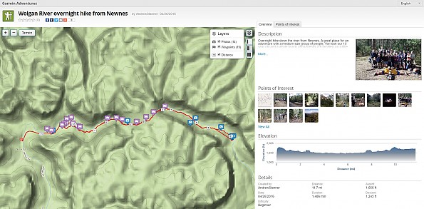
Some of my friends were quite impressed.
Geocaching
I had never been GeoCaching in my life. The GPSMAP 62st supports geocaching GPX files and seems to do it reasonably well. I found the process tedious and have not worked out yet how to do more than one at a time. I could not get the file transfer function to work with a Chrome browser, but did succeed with Internet Explorer. I suspect that this is common for all GPS units and nothing to do with Garmin.
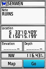
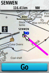
This is what a GeoCache looks like on the screen (I don't have a "Premium Account). The text, hints etc do not appear, you have to do your research offline or else carry a phone with you. I saw another review from a bloke who did have a premium account and the GPSmap 62st did then display a lot more information. There is a limit to how many geocache's can be stored, about 5,000 I believe.
Custom Maps
Garmin has a very nifty feature / software called "Custom Maps" which works really well with this unit. It may well work with all Garmin GPS units, not sure. I found a map that was more than 100 years old of an area that I wanted to explore. You simply scan and save the map as a picture, load the map to Google Earth as an image overlay, size, scale and align etc, and then port it into the Garmin as a custom map. Quite impressive. I can see myself using this to map some of the old army forts around Sydney Harbour for OSM.
User Interface
After a few days effort (yes, days) I did start to understand the user interface. In the modern smart-phone world, going back to "buttons" seems strange, but buttons do work in wet weather and also wearing gloves. Many functions work with only a few button presses which is quite effective when you "learn" the system.
But there are some silly little things that I found really annoying:
- I made the mistake of loading lots of Waypoints. Bad news because you can only slowly scroll through Waypoints, at a little over one per second. So if you load 100 waypoints and want to go to WayPoint Zulu, you need to allow a minute or two of scrolling down from A to Z. Scrolling up to get to the end is not allowed! Duh! After using it for a month I discovered via Google that the "Out" button is the same as "Page Down".
- Screen capture. One of the joys of hiking is planning, sharing and collaborating. As well as I can determine the "screen capture" function turns itself off every time you restart the GPS. Tedious!
- Elevation graph. One of the great features of this unit is the barometric altimeter. But the graph it produces does not have well labelled X and Y axes.
- GeoCaches suffer the same problem as Waypoints. Don't load too many because you lose the ability to easily scroll. There is a "find" function but good luck with that. I recommend that you are selective. As well as I can determine from other reviews you are limited to 5,000 anyway.
The number of features and functions is huge. The "menu" button seems to get to most of them in a vaguely logical order, but whatever you do learn how it works before you leave home. I feel that it is dangerous to be learning in the bush with this device!
Instruction book and help information
The 60-page instruction book is woeful! The truth is that there are so many features and functions of this GPS that it would probably take a 500 page instruction book to cover them well. For example the instruction manual covers how to delete waypoints, delete routes, delete tracks, delete photos, delete a profile, but if you want to delete a map because you are running out of memory then you need to find the answer on Google. Thankfully the user community is large enough that someone somewhere in the world will have the same problem.
There are a myraid of other features and functions that also appear to be completely missing from the manual. A couple of examples I discovered are listed below:
- USB drivers. There is no mention whatsoever of USB drivers in the owner's manual. I could not connect my device to my PC and I was not getting any error messages that indicated a problem. It was pure luck that in my efforts to connect the device, I stumbled across a post on Google that suggested loading the USB drivers.
- I was out learning how to GeoCache and selected "Setup Geocaches" and a feature called "Chirp" appeared. Assuming it was related to GeoCaching I explored the functionality. There is no mention of what "Chirp" is in the user manual. After much faffing around I gave up. Later when I got home I discovered Chirp is a Garmin sonar technology. It is illogical and confusing to have a menu option like this available for mug users with no explanation on the device or mention in the instruction book! Correction: I later discovered that Garmin also has a Chirp geocaching beacon.
One reviewer said that there are dozens of important features that are not covered by the manual.
The list of failings relating to the instruction book and online help could go on for quite a while; particularly in relation to the software that almost all users will use in conjunction with the device. The help information for BaseCamp is even worse. The user forum is also particularly poorly structured. Rant finished.
Some enterprising person has created an unofficial Garmin BaseCamp wiki in wikispaces. It is probably the best source of information that exists. Kudos to you whoever you are.
Finally, there is next to nil help information on the actual device itself. Seriously, how hard would it be to add a "help" option at the bottom of each menu option with a brief description of each function.
Maps
No GPS review would be complete without some consideration of the various map options. Garmin scores pretty well in the map department because they appear to design their units to accommodate paid, licensed, free and custom maps. This is a big bonus and puts them well in front of their competitors. Because the user community is so large, there are many options to obtain and download maps. But my unit only had a very basic map pre-installed for Australia. But Google and Apple maps will change this over time.
My new best friends at The Outdoor Gear Lab said that "If you want the best maps spend some time tinkering with the free data. If you want something low effort be prepared to shell out around $100 for maps from a manufacturer." Add another $100 to that for Australian dollars. The Garmin TOPO map costs almost $200 in Australia which is a crazy amount of money for a map that is not transferable to another device and is only 160 pixels wide. Seriously it works out at more than $1 per pixel (width).
Thankfully there are quite a lot of really good free options available. Some of the best that I have discovered so far for Australia are as follows:
- In Australia the Government (Geoscience Australia) have released the entire 1:250k mapping series for free for non-commercial purposes and some enterprising people (notably ShonkyMaps) have done the conversion to Garmin format and provide the download for free. The quality is superb. Contours at 50m intervals. Cliffs are shown and most roads. It is not routable if you are driving but for outdoor use it is superb.
- In NSW (where I live) the Government has released the 1:25k maps online for free on maps.six.nsw.gov.au with extensive conditions (including not storing and caching etc). This map data is not free on the Garmin so most users still need to buy a paper map. I have not seen the paid TOPO maps sold by Garmin but I can only assume that they would be similar in quality to the base data which is licensed mainly from the various state governments under similar conditions. The Garmin maps cost almost $200 in Australia which is absurd for a screen that measures 160 x 240 pixels. I am guessing that most users go for one of the free options.
- For OSM maps, there are a gazillion sources and I have tried several. For the Garmin my tip is that the best I have found so far is mapas.alternativaslibres.es but it does really depend on what you are using it for. Formatting makes a lot of difference. A lot are almost unreadable.
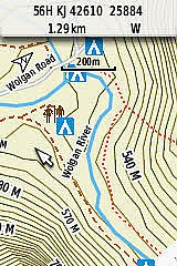
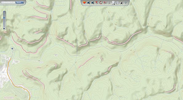
I am going to digress slightly here but this is a sample of the NSW map data available at 1:25k. This is available online for free but to get it on your Garmin you need to pay the $fee. This is the Wolgan River east of Newnes in NSW, Australia.
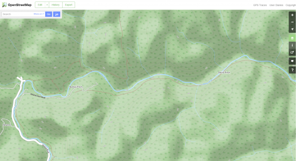
By comparison, this is a sample of the Open Street Map (OSM) data for the same area.
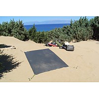
A photo of the same valley follows:

A casual observer will quickly see that the OSM contours have serious problems. This area is covered with cliffs, some of them up to almost 300m tall. None of the contours indicate cliffs on the OSM map. This is touted by some as the second largest canyon in the world (based on width I think). It is my understanding that the reason is that OSM uses NASA's Shuttle Radar Topography Mission (SRTM) data for contours. The problem is that the Space Shuttle radar was only sensitive to about 30 metres, so any cliff smaller than 30m will not show on the map. But many of these cliffs are over 200m tall, and some almost 300m tall and they still don't show. Beginners beware. Because of the very poor contour data there are huge cautions with relying on OSM maps. But the OSM maps do a far better job of showing tracks and names, particularly for the interesting places.
I read online that some clever people have figured out how to create a transparent layer with ShonkyMaps 50m contours (free) and superimposing that over OSM base data (without contours) which is also free. That gives the user the best of both worlds.
Bottom line is that the digital maps can be dangerous and the quality varies enormously. Beware.
Digital compass and dashboard
Finally, the 3-D digital compass. I always thought that these were a bit of a gimmick but it only took one hike to see why this is a premium feature and why it is a real enhancement over the base model GPSmap 62. You can set the compass to digital (grid) north so that eliminates the old magnetic to grid conversion for beginners. You can hold the compass up at an angle and almost use it as a sighting compass. And if you program in your waypoints etc you can see distance to destination etc at a glance on the dashboard which is very user friendly. One knowledgeable reviewer said that he had his set-up with the map as the default screen, and toggle the "page" button once backward to get to the dashboard.
Summary
I did find it hard initially but now that I am over the learning curve I have a lot of confidence in this unit. It is a great unit and my "Top Pick".
The thought has occurred to me that perhaps I bought the wrong device. This should perhaps have been sold as a quasi-professional device with a warning label that says that it is a complex professional instrument and amateurs should go elsewhere. But I am the target market for this GPS. A gear freak, comfortable in the outdoors, technology expert, and not afraid of adventures that will take me into places where lesser GPS units will fail to get a signal.
The Outdoor Gear Lab gave it 81/100 and made it their "Top Pick" but it is only averaging 3.2 stars on their website. That suggests to me that most users don't appreciate all the features and functions.
I bought mine in almost new condition off a very nice bloke who had never learnt how to use it. The hardware is worth five stars but the user manual, UI and Basecamp software need a lot of polish. I am going to give it four stars.
This was a good buy second-hand. There are a lot of old Garmin eTrex units being sold second-hand after 10+ years. I fully expect that my GPSMAP 62st will last me the next 10 years. It is a solid, rugged, reliable and accurate unit.
Source: bought it used
Price Paid: AUD$220
![]() Reviewed by
Reviewed by
PAF56
+32
 March 30, 2016
Hand draw your route in Base Camp.
My problem with Base Camp and all other back-country mapping software, is that you can't just put in the starting point and the end point and any waypoints in-between. You must manually hand draw on your computer the actual route you want to take as precise as possible, then transfer that route to your GPS. It won't just route itself on the trail, like a street GPS follows a street route.
WHY NOT?
This is 2016!
Precision is required if you are wanting any kind of accuracy in your Trail Profile and Mileage.
Source: bought it new
Price Paid: ???
Your Review
You May Like
Specs
| Price |
MSRP: $549.99 Historic Range: $314.93-$549.99 |
| Weight |
9.2 oz / 260.1 g with batteries |
| Dimensions |
2.4 in x 6.3 in x 1.4 in / 6.1 cm x 16.0 cm x 3.6 cm |
| Display size |
1.43 in x 2.15 in / 3.6 cm x 5.5 cm, 2.6 in diag / 6.6 cm |
| Display resolution |
160 x 240 pixels |
| Display type |
transflective, 65-K color TFT |
| Battery |
2 AA batteries- not included, NiMH or Lithium recommended |
| Battery life |
20 hours |
| Waterproof |
yes (IPX7) |
| Floats |
no |
| High-sensitivity receiver |
yes |
| Interface |
high-speed USB and NMEA 0183 compatible |