 by Alicia MacLeay
(Continued from Part Two)
We awaken at dawn to the sounds of a moose lumbering toward our tent. The animal’s heavy footfalls pass nearby and then eventually fade away. We wait a few minutes before deciding we’re fully awake and heading down to the shore of C Pond for our own breakfast.
Dave and I arrived at camp after dusk last night, when the fading light didn’t allow for much observation, but this morning we absorb the serene setting from a log on the sandy bank of C Pond. Peregrine falcons call from their perches high above in the cliffs of C Bluff. On the southern shore a deer drinks. Somewhere on the opposite shore is Warden George Learned’s camp, where the Bates boys spent two nights, but if it’s still standing it’s hidden from our view behind dense trees.
The cozy setting moved the usually pragmatic Bates boys. They wrote the following in their scouting log after fly fishing (fruitlessly): “The pond was a beautiful scene with the mists partially obscuring the ledges of C Bluff and the water light and tranquil while the dull sky became brighter as the day was born.” Not unlike our own experience.
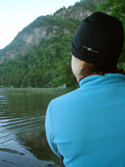
The author contemplates possible routes up lower C Bluff.
Getting to the top of 2,799-foot C Bluff Mountain is our next mission. From shore it looks steep, rocky, dense, though a ridge angling up the western side of the bluff promises a route to the top of the cliff. The entire Bates party made it to the summit, ultimately blazing a spur trail here for the AT. Surely we can gain the ridge and make our way to the top without too much trouble.
Dave and I pack up camp, stash our gear, and start up what looks like a very promising trail, practically a road, toward the bluff. It quickly ends in thick berry bushes, brush, and a stream. Back to bushwhacking.
Working around the pond counter-clockwise below the cliff we make our way over moss-covered logs and soft ground that gives way beneath our once-again soaking feet. We find the remains of two blue blazes on trees along the shore, confirming that we’re on the Bates boys’ path. Despite the blazes, we soon lose any semblance of trail and try angling upward. We gain elevation, weaving our way over and around ever-larger piles of boulders and rocks, and across soft ground littered with moose and bear droppings.
Drop-offs and precariously stacked boulders frequently force us to back down and look for a better way, often for any way, up. Across the pond in the trees, we can now see the shining roof of a cabin. It must be Learned’s, where Sam and his friends celebrated his 21st birthday.
After countless dead ends, we reread the scouting party’s log and trail descriptions for a hint of the Bates group’s course. Their total description of the ascent: “This proved a hard tough pull, going all the way straight up.” Indeed.
The Bates group spent a full day on that first ascent and Dr. Sawyer, Sam, and Learned returned the next morning for yet another climb, “not being satisfied with yesterday’s trip.” But Dave and I have miles to cover today. After a few hours exploring C Bluff we head back toward our packs. I’m disappointed to miss out on the summit: “the view from this spot is truly wonderful,” despite the “back-breaking return” the party wrote. We just need more time, and patience. I wonder when we can come back and try again.
The Bates scouting group was just as intrigued by this place. Although the original AT passed by without summiting C Bluff Mountain, Bailey would return with other members of the Bates Outing Club the next summer to work on a spur trail here. Even after his previous visit he’d write that at first they “didn’t find any feasible way” until they happened upon an old game trail, “through the densest of blow down.” The only remaining testament to that trail is a pair of faded blue blazes near the shore of C Pond.
Back on the scouting party’s route we follow old, muddy, overgrown tote roads, crossing a rocky stream and passing a beautiful small gorge. It’s peaceful and leafy. I could follow this all day. But eventually we’re back on more recent logging roads, passing through rough, scrubby log yards. Following a modern logging road is simple enough. Walking on one for miles is another matter. I feel every rock and stick underfoot.
By mid-afternoon we’re climbing the abandoned trail alongside Clearwater Brook between Elephant and Old Blue mountains. It’s beautiful along this mossy brook, despite the dense blowdown. It’s here that we see the white blaze on a rock near an overgrown log of a bog bridge. That white patch of paint spurs me on.
Eventually we top out on yet more logging roads, which have obliterated this section of trail. Then end up back on the trail, still abandoned but more heavily used by peakbaggers headed to Elephant Mountain. When it ends we step out of the trees and onto the AT—the current Appalachian Trail that is—complete with trail sign.
It strikes me. I can turn left and head north to Katahdin, or turn right toward Georgia to the south. Just walk and follow the white blazes. That’s the AT. It’s as simple and as remarkable as that.
We motor north a few miles and I’m lost in my thoughts. Where a tree has fallen across the trail someone cleared a path with a chainsaw. Rock steps ease the way up a steep section. This is the AT I know. It’s familiar, comfortable, fast. No longer must I repeatedly look over maps, a GPS, and trail descriptions to plot my next step. I just walk.
Being on the AT after miles of abandoned roads, trails, and bushwhacking gives me a better appreciation for trail builders and maintainers. But I also lose something. The past two days off trail I’ve been more aware of my surroundings, more mindful of myself, my path. Now I have trail hypnosis.
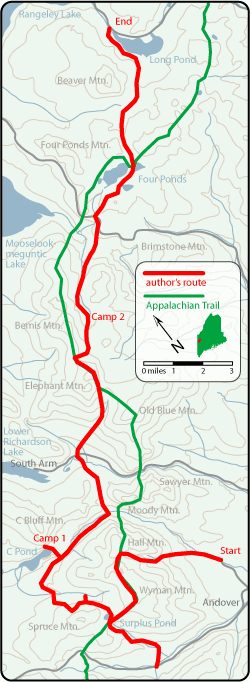
We leave the AT at the Bemis Stream Trail and make camp between clear cuts in the valley below. We’ve covered 12 miles today and tomorrow will hike 14 more to reach Long Pond near Rangeley—the end point of the trek for the Bates boys, and for us.
The final section takes us by Four Ponds, a popular fishing spot in 1934, and today still dotted with cabins. The Bates party caught trout for dinner here. We follow a warren of foot and snowmobile trails cut through thick spruce on the south shore of Long Pond. At several junctions we deliberate on our next move, only to find yet more signs of the AT further down the trail—a blaze, moose antlers emblazoned with the AT symbol hung on a tree —rare rewards that make me walk a little faster.
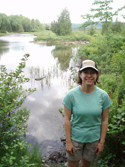
The author reaches the outlet of Long Pond, and the endpoint of her trek.
The last miles take us over an old fire road, now mostly bog, in which I manage to drop and submerge my camera. Later I learn that Bailey fell on his own camera the very first day, after which “it did not function properly.” Luckily ours survived its dunking. Then it’s a long road walk to the outlet of Long Pond in Rangeley. We reach our destination at 5:30 p.m. We take a few pictures by the pond. Change our socks and shoes. Eat a celebratory chocolate bar.
I’m glad to have followed my great-uncle’s AT scouting route. Thankful to have seen some of the same spots he did, beautiful ponds, forest, and streams I wouldn’t have found had I stuck to the usual trails. I have greater admiration for him and his companions, for their navigation, their hard work, and their role among many in building the 2,000-mile Appalachian Trail.
The end of the hike doesn’t bring closure though. I naively expected that by following Sam’s route I’d somehow know what this whole thing meant to him, what he experienced, what it was like to be part of this historic project—completing the AT's final, missing link. Instead I’m left with more questions. How could we get up C Bluff next time? How closely did our route really follow theirs? Did they see as much wildlife as we did, and just neglect to mention it? (They do note a porcupine dispatched with a 38 Colt, another killed with stones, and one inquisitive deer.) Or were the woods quieter then? And ultimately, how would I truly have fared on their 1934 trip? Some questions can be answered, others can’t.
At the trip’s conclusion the students wrote in their log, “and so has come to an end a week’s hard work—but work that has meant a lot to us and was very worthwhile. Everybody is satisfied—tired but happy.”
I may not know Sam personally, but I can understand that.
Epilogue
A few weeks after our trip, I find myself in the archives of the Maine State Library. Here I discover a copy of Professor Sawyer’s detailed report to ATC chairman Myron Avery, dated July 13, 1934. It is filled with highly detailed directions and mentions a map and pictures, which I can’t find nearby. Initially I’m disappointed that I didn’t get a copy of this report before our trip, and inevitably I wonder about the map and photos. Would they have saved us some time, some frustration and confusion?
Ultimately I’m glad I didn’t have them. Even if the same landmarks were still there seven decades later, they weren’t necessary. I wanted to follow Sam and his companions into the woods to better understand their own trip. A little frustration and lack of information is par for the course. They did it with the best information available, and so did we.
In his reply to Sawyer, Avery wrote: “With them, I have had, this evening, a most thoroughly enjoyable trip in the Maine Woods. There is hardly anything I can say about the report. It is a classic. … Anyone who reads the report will appreciate how thoroughly you have scouted and obtained the data on this region. It is a perfectly done piece of work and to say that you and your cohorts are to be highly recommended is a regrettably mild way of stating it.”
As Avery goes on to tell the Bates boys, thanks to them: “The Maine problem is pretty well gone now.”
Special thanks to Brian King of the Appalachian Trail Conservancy; Pat Webber, archivist in Bates College's Special Collections; the Avery Collection in the Maine State Library’s Special Collections; and the Maine Appalachian Trail Club. Belated thanks to my late, great-aunt Hazel Fuller (Sam’s sister-in-law) who passed on her copy of the Bates trip log years ago.
For more information on the development of the AT:
“An Appalachian Trail: A Project in Regional Planning” by Benton MacKaye (Journal of the American Institute of Architects 9, Oct. 1921) (PDF)
Trails Years: A History of the Appalachian Trail Conference, editor, Robert A. Rubin, (Appalachian Trailway News, July 2000) (PDF)


