 It's easy to find facts on your favorite parks online, but until recently it wasn't so easy to find them all at the same site. That's changing with the rise of Oh, Ranger.com, American Park Network's online companion to its series of "Oh, Ranger" guides to America's most popular national parks.
The most promising feature at Oh Ranger is also the most prominent: A list of recent questions asking APN's experts how to do things like choose routes for backpacking trips to Yellowstone or finding lodging near Yosemite. More than 500 questions have cropped up in the 36 weeks since Oh Ranger began answering them last year.
There's a wealth of information on national parks, and a respectable representation of state parks. One glaring omission (for now anyway) is probably intentional: pages describing park features are devoid of the maps and graphics you'd expect in a guidebook. If you want all that from American Parks Network, you can grab a free guide at hotels, RV parks, and tourist sites near the national parks, or you can pony up cash for their print guidebooks ($19.95 for the whole set; link available at the bottom of the home page). Either way, stuff you'd like to see on the site is somewhere else.
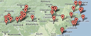
 One handy feature for travelers is a U.S. map that lets users click on a state to see all the major parks within its borders. I clicked on North Carolina, my current locale, and found an extensive list integrated into a Google map; all my favorite nearby hiking haunts are included. Note the map can have many pages so you might have to click on a few to find your favorites.
Another feature that allows scanning for a range of activities within a certain radius of a specific locale was unimpressive at first glance (It gave me 21 hikes with 25 miles of San Francisco, a laughably low number for that trail-rich region). Links to Google maps within individual park pages need some help, too: Yosemite National Park's map link lands on Tioga Road, which is closed more than half the year, instead of the more obvious Yosemite Valley, which is open all year.
Oh Ranger is still in its shovelware phase: text from its print guides has been cut and pasted into its web pages, and some of the inevitable type formatting errors are still in the text. Here's hoping the brush'll get cleared as the site emerges from its "beta" phase.
The site's far from perfect at this phase, but it's built on a sound principle. If folks stop by, use its features, and prod improvements from its publishers, it'll get better.

 by Tom Mangan


