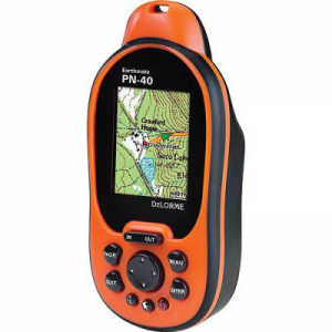
DeLorme Earthmate GPS PN-40
The Earthmate GPS PN-40 has been discontinued. If you're looking for something new, check out the best handheld gps receivers for 2026.


![]() Reviewed by
Reviewed by
Mark Goresky
 June 4, 2009
I really like this unit. I've owned a number of portable GPS units, stating with a Garmin nautical GPS in 1991 (at 3 pounds and 2 feet long, it wasn't really a handheld); a Magellan handheld unit (since lost, so I can't tell you the precise model), a Garmin Etrex Legend, a Delorme PN-20 and now the Delorme PN-40.
Every 5 years, GPS capabilities have improved and I've been absolutely pleased with each of my purchases (less pleased with the PN-20, see my review in these pages). But I'm more than pleased with the PN-40: it is a truly amazing little gadget. Delorme has fixed the limitations of the PN-20 and has gone on to add all kinds of further improvements.
Of the various features of the PN-40, three of them especially appeal to me: (1) rapid acquisition, (2) ability to handle huge SD cards, up to 32 GB, (3) Topo maps of the whole USA plus street maps of the US and Canada.
In my back yard, which is ringed with tall trees, I did a "cold acquire" (meaning that I hadn't used the thing in about 2 weeks). Within a few seconds of turning it on, it found 6 satellites (showing red bars, indicating a signal received but not yet usable) and within 40 seconds, all the red bars had turned green and it had a 3D fix. A "hot acquire" (meaning that I turned it off, waited a few minutes, then turned it back on) took only 10 seconds, and two of the satellites had WAAS fixes as well (indicated by blue bars).
This is a huge improvement over the PN-20, and it is among the fastest receivers I have ever seen. (The PN-20 map display also became quite slow if the memory card was loaded up with maps; the PN-40 doesn't seem to suffer from this deficiency.)
TOPO-USA maps are pretty good. I currently have version 7 but ver. 8 has recently been released and I've sent in my "free update card" (good for 6 months after you buy the unit; be sure to keep the UPC code from the box) to receive them. Delorme claims TOPO-USA ver. 8 is much improved, and it is true that ver. 7 maps are a bit spotty when it comes to their coverage of hiking trails, but I've found them to be decent.
I did some hiking in various dry washes of the Anza-Borrego desert in California, and they were all indicated on the maps. (It's pretty hard to get lost in a dry wash which may only be wide enough for one person, but once you've climbed out of one wash and into another, and done that a few times, suddenly they all start to look alike, and having a GPS may be the only way you can get back to your 4x4.) With the huge memory cards, you can load the whole USA into the GPS, and throw in all of Canada too, and still have room for aerial photos and such.
Street maps: Even without loading the DVD containing "street maps of the US and Canada", the street maps in TOPO-USA are great. I've used them while driving (or rather, my navigator used them) in the car, trying to find our way to a road in central NJ. The PN-40 saved us from a number of wrong turns.
The first release of the PN-40 did not provide any maps of Canada, and so far as I know, the PN-40 still doesn't work with Street Atlas USA (why the heck not, Delorme???) but it appears that the Canada/USA street maps that are now bundled with the PN-40 are pretty much the same as Street Atlas USA, so I'm happy now. Wish list: Topo maps of Canada; street maps of Europe, please.
Other features: I only have comments on four of the many additional features of the PN-40:
--The display is bright and clear; I can read it in midday (as long as I'm wearing my reading glasses: I'm on the "wrong" side of 50 years); the colors are spectacular.
--Delorme fixed the "go to waypoint" function that I complained about in the PN-20 review; in fact they even fixed it in the PN-20, not long after I wrote my review. It is now very easy to click on a waypoint and find your way back to it using the unit.
--The PN-40 comes with "pre-cut" topo maps which makes it much easier to load them into an SD card. For the early PN-20 units, you had to run TOPO-USA on your (windows or mac) computer, select the regions you were interested in, select the range of magnifications you wanted, then click on "download" and wait, sometimes for quite a while, as the computer re-coded those map regions in a format that could be used by the PN-20. The whole process is fast and efficient with the new pre-cut maps.
--I don't really use the downloadable aerial photos, but I did test them out: Delorme has developed a remarkable overlay system that places the aerial photos exactly on top of the topo maps, much as Google Earth does. If you've ever tried to do something like this by hand you'll appreciate how clever Delorme's and Google's algorithms must be.
Disadvantages:
The first is the price. (I bought mine through Amazon which had the best price at the time. It has come down a bit since then.) It's no more expensive than similar units with similar capabilities, but it's still a serious amount of money, plus you'll want to shell out another $30 or more for a high capacity SD card. (It comes with a 1 GB SD card which for most purposes is adequate if you're willing to "cut" the maps that you are likely to need, and then to install them on the memory card. But it's much easier to get a huge memory card and then dump everything into it.)
Second disadvantage is the size and weight: it is a little bulky, and it's not because of the LCD screen. The LCD display is 3.5 cm x 4.3 cm. = 15 square cm. The glass area around the LCD display is not rectangular, but it has about 30 sq. cm. So if the whole glass area was LCD (probably technically infeasible) this would double the screen area, which would be great. With batteries, my unit weighs 7.1 oz. and it is 3.5 cm thick. For comparison, my Garmin Legend with batteries is 5.4 oz, and only 2.7 cm thick. The Garmin's screen area is 3 cm x 5.5 cm = 16.5 sq. cm., which is nearly the same size but less square. I'm sure Delorme has crammed everything into the tiniest area they can, but you'll be carrying around something that you wish was a bit smaller.
Third disadvantage is battery life: like most GPS units, this thing is hard on batteries, and (also like most gps units) it drains the batteries even when it's turned off, because it's keeping track of the time. So if you haven't used it for a few months and then you go off on a trip, be sure to start with fresh batteries (and take along a couple of spares as well).
Yes, it's true that I'm getting soft. I used to hike with topo maps and a compass, and I had a sense of accomplishment at the end of the journey. But the GPS is so darn convenient: no folding/unfolding; you don't run off the edge of the map; you don't worry about the rain getting the map wet, you don't spend an hour rummaging through your map collection, searching for the right topo maps before you leave on your hike while your hiking partners are out there waiting for you in the car with the engine running. I have friends who have sworn never to use GPS, and I completely agree with their point of view, but for me, the PN-40 is the right solution.
No, I am not paid by Delorme, nor have we ever been in contact. They didn't even ask me to remove my complaint about the PN-20 after they made the software correction. I just like this GPS and I've even gone out on a limb and recommended it to several friends, who, it seems, are still talking to me.
Price Paid: $245
![]() Reviewed by
Reviewed by
steverod
+75
 March 31, 2010
This is a solid, but frustrating, GPS with high bang-for-the-buck value.
It has a bright display and the option to use all sorts of maps, including aerial photography and USGS topos, but it and the PC software to use its biggest features are somewhat cumbersome.
I bought the predecessor to this, the PN-20 (which was my first GPS), and it was very nifty but v-e-r-y s-l-o-w. (When I can hike faster than the screen can update, that's slow.) When DeLorme announced the PN-40, I switched and have been using it off and on for more than a year, for a combination of day hikes and backpacking trips. One of the PN-40's big selling points is its paperless geocaching, but I don't geocache.
Things I like about the PN-40:
- bright screen: the screen is bright and clear and easy to read.
- free road routing: the unit includes 1:100K topo maps of the entire US including routable roads. The included software (Topo USA) will do routing on roads and trails and transfer those routes to the PN-40.
- lots of map imagery: The unit comes with a coupon for free data imagery and you can buy a subscription from DeLorme, to have real (scanned) USGS topos, aerial imagery, etc displayed on the unit. It's really cool to have your GPS show you exactly where you are on a USGS topo, and then be able to switch to an aerial view.
- dedicated waypoint button: makes it really easy to place a waypoint Right Here.
- customer/technical support is GREAT. Sadly, I had problems with my unit, but DeLorme tech support was really knowledgable and easy to deal with.
Things I don't like about the PN-40:
- signal acquisition and retention: hiking in the SF Bay Area, which is pretty thickly forested, I have lost GPS reception or never been able to (re)acquire it several times. It's particularly bad when I haven't used the unit in more than a few days, which is most of the time -- I'm lucky if I can get out once a week (sigh). This has improved through the various software releases but it's still not as good or as reliable as my Garmin Oregon. (It has worked fine in the Sierra Nevada.)
- battery life is AWFUL. I have used both AAs and the DeLorme Li-Ion rechargeable battery in this unit. Usually a day hike (not a full day, mind you) is enough to drain a pair of AAs and I might get an overnight backpacking trip out of the Li-Ion if I'm really careful. On the plus side, it has a built-in charger for the Li-Ion so you can recharge the battery in your car while driving to and from the trailhead.
- The unit really forces you to use the DeLorme Topo USA software. If you geocache (again, I don't), they have mechanisms to get geocache data on and off the unit, but to transfer maps, routes, waypoints, etc. you need to use Topo USA. Topo USA is Windows-only (I use a Mac) and while it is incredibly powerful, it's also really hard to learn and get started with. You can't even get GPX files (standard for transferring GPS info) on and off the unit without using Topo USA, and it's not really obvious how to do so.
- You can install different imagery types, but you're restricted to what DeLorme provides. There is a mechanism to install custom user data but it requires buying DeLorme's XMap Pro software for another $100.
Things that bug me but aren't really THAT important:
- Typing (to enter waypoint names, descriptions, etc) is annoyingly slow. You have to scroll around to select each letter/number/etc. DeLorme's done the best they could by having shortcuts but that only ameliorates the pain a bit. But every GPS has this problem except for the Garmin touchscreen units.
- It's not "pretty." I find this embarrassing to admit, but my Garmin does a really nice job of presenting map information visually; it's a nice-looking map and it's easy to understand what it's presenting. The DeLorme maps are just not as smooth, not as easy to read. It's like comparing a Windows 95 display to Windows 7, or even XP -- there's nothing wrong with the former, it just doesn't look as good.
- Continuing with that theme, the 'feel' of the device is similarly clunky; this device was created by a bunch of GPS geeks who are not UI designers. There are lots of options and lots of controls and you can get the unit to work exactly the way you want it-- but there's a learning curve to get there.
In the end, I found myself liking the unit but frustrated enough by its flaws (especially the battery life) and annoyances that I wound up buying a Garmin Oregon, and I find myself using that a lot more. But the Oregon is easily twice the cost, even before you include all the map data that you get for free with the DeLorme. (And you can get a lot of legal, free mapping data for the Garmin units if you're willing to hunt a bit on the Internet.)
As I said above: the value of what DeLorme provides with the PN-40 make this a great buy, but it also has some serious drawbacks. If you can deal with those, you will find the PN-40 to be a really good unit.
Price Paid: $399
![]() Reviewed by
Reviewed by
NoleAnimal
+24
March 12, 2009
If you are looking for a handheld GPS that you can also use in the car, stop reading and go look at Garmin's website or somewhere else. This is not the GPS for you. If you are someone who wants a GPS to give you the basics and is as easy to use as a "point-and-shoot" camera, this is likely not the GPS for you. If you are a hiker, hunter, mountain biker or any other kind of outdoor enthusiast that needs a powerful land navigation tool... this is the BEST GPS going.
I will start with the negatives. The biggest is that the mapping software that comes with the PN-40 takes some time to get used to. It's not bad software, it just takes some time to learn how to use many of the more advanced features. That being said, you can be up and navigating almost immediately. Also, the forums on Delorme's website are FULL of excellent people more than willing to help you with any questions or issues.
The second biggest negative is that it eats batteries pertty quickly. Get some GOOD rechargables and you will be okay.
The third is the small screen size. Honestly, there is no way to mitigate this, you just have to deal with it. Considering the overall package though, this really turns out to be a minor inconvenience.
Now, the positives. I could go on and on about this but I'll try to keep it to a minimum. The biggest advantage of this GPS over its competitors is the cost of getting additional maps. For $29 A YEAR, you have access to DeLorme's (a map company by trade) online library of maps with unlimited downloads. This includes their base maps, USGS 7.5 minute quads, Color Aerial Imagery, Black and white aerial imagery, NOAA Nautical charts and Satelitte imagery. And the unit itself can display any of those on screen as the navigation map. Yes, actually aerial imagery like you see on Google Maps can be used to navigate.
Another big advantage is the accuracy. I have never used the Garmin 60Csx (the standard in handheld GPS accuracy) but from what I have heard it is very close. Based on my usage, I can tell you that I can easily tell which side of the street I am walking on in my neighborhood. My wife had it in the car once and I could tell which side of the garage she parked on.
The third major advantage is the Topo7 software that comes with the unit. True, it's takes some effort, but it is insanely powerful and quickly becomes an indispensable tool.
Some others nice features are the fact the unit is light and rugged. The screen is easy to see in direct sunlight. It can use up to a 32GB SDHC card to hold a TON of maps or imagery. It has sunrise and sunset data, a compass and altimeter, and even hunting/fishing forecasts.
I was very hesitant to spend a lot of money on a GPS when I was looking at the Garmins and the Magellans because I could not find one I really thought was perfect. I am so glad I found the Garmin, it's a GREAT unit.
Price Paid: $350
![]() Reviewed by
Reviewed by
steviegilbert
+7
 April 24, 2011
This is the first GPS I have owned so having nothing to compare it to. I truly love this device. I have to agree with the other reviews that the unit is big and clunky and a bit goofy to navigate at first but once I got the hang of it I found it rather easy to use.
I mainly only use my unit as a tracking and navigating source for backpacking trips which it performs flawlessly for. I am able to trace my trip then return home and transfer that data to the software on my computer.
My lack of technological skills makes this unit the ideal mate for me. No fancy bells and whistles, just good ol navigation.
 Reviewed by
CALDGARGAN
+2
January 3, 2010
This is an easy to use device. It has all the features that you need for any type of hiking adventure. I find it easy to read. To test it out I took it cross country through heavy woods between trails. It is fast, and accurate. Loading in waypoints is a snap.
The only thing I did not like was the computer interface. It took a few days to get it to work right--I followed the instructions to the letter, it just for some reason would not load up the maps I needed.
Price Paid: $299
 Reviewed by
kayakingdog
+73
 November 18, 2011
Very good unit. Great color screen, with the ability to upload maps. Waterproof, and drop proof.
Only drawback is it eats the batteries.
Price Paid: $250
Your Review
You May Like
Specs
| Price |
Historic Range: $199.98-$399.99 Reviewers Paid: $250.00-$399.00 |