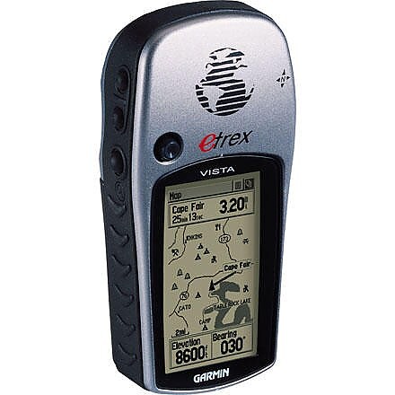
Garmin eTrex Vista
The eTrex Vista has been discontinued. If you're looking for something new, check out the best handheld gps receivers for 2026.


![]() Reviewed by
Reviewed by
Nick Mackenzie
 August 25, 2006
I have used this device for years and would be happy to purchase another if I ever needed to replace it. I've used it to map trails and build maps for the BLM where I particpate as a volunteer, teach land navigation techniques, find my way in a strange city and most recently, record a twelve-day hike covering 80 miles and 15,000 vertical feet at Philmont in North Eastern New Mexico. After that hike I successfully downloaded my 80 miles of track and waypoint data into Google Earth and shared the images with particpants on the hike. On that hike I was able to use the unit continuously while hiking and it consumed two AA Lithium batteries every 2.5 days.
Garmin's easy to use, web based software updating service has enabled me to keep the device current. I like its ease of use and small size make it convenient to carry on my pack's shoulder straps. Like all GPS devices, it performs best when it has a clear view of the sky so placement on your pack or person requires some thought. Remember that the satellites are 20,000 km above you so the radio signals are weak. The Vista's barometer is quite accurate and the auto calibration feature performs quite well.
Price Paid: unknown
![]() Reviewed by
Reviewed by
Jeff
September 4, 2004
This is a good GPS unit, small, lightweight. It is very easy to use and the screen is detailed. I love the ability to load maps using Garmin's Mapsource and Topo maps.
The only downside is the reception. Most of my hiking is above tree line, where the unit functions flawlessly. However on a trip through low density forrest the unit was seldom picking up a signal. I would find an area where there would be no trees, and sometimes I could get a signal.
Overall it is a good unit, but not if you use it for hiking in dense forrests.
Price Paid: $299
![]() Reviewed by
Reviewed by
ROMADOZ
+43
 October 31, 2007
Quite possibly the best GPSr I have ever used. I am military and an active geocacher, as well as a Scout Master. I have used mine for all purposes without fail. The one I am using now has been with me for 6+ years. The buttons are worn a bit, and the case is scratched from HEAVY use but still working. I have 4 GPS units, this and my 76CS get used at least weekly if not more. Do yourself the favor and get the TOPO or Metro maps for it.
Price Paid: issued by military
Your Review
You May Like
Specs
| Price |
Historic Range: $99.93-$399.99 Reviewers Paid: $299.00 |
| Weight |
5.3 oz / 150 g with batteries |
| Dimensions |
2.0 in x 4.4 in x 1.2 in / 5.1 cm x 11.2 cm x 3.0 cm |
| Display Size |
1.1 in x 2.1 in / 2.8 cm x 5.4 cm |
| Display Resolution |
160 x 288 pixels |
| Display Type |
4 level gray LCD |