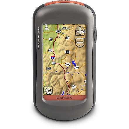
Garmin Oregon 450


![]() Reviewed by
Reviewed by
Raymond
+35
 November 11, 2012
Sturdy. Nice-sized screen. Touch-sensitive screen. Waterproof.
Pros
- Does what it is intended for
- Waterproof
- Touch screen
- Good battery life
Cons
- Useless installed maps for hunting
- Only basic "Quick User" guide included
Ease of Use: I think this is a great hunting and hiking GPS unit. Everything is easy to use and understand. The icons are large, and pretty self-explanatory. You install the batteries, turn it ON, wait a minute for it to acquire the satellites, and you are ready to go. If you want to be more accurate, take the extra minute to calibrate the 3-axis compass and fine tune some more of the instruments).
If you ARE NOT GPS savvy, then it bites that Garmin did not include their full User Manual with the device. (You only get a skimpy 4 or 6 page Quick Guide flyer). At nearly $300, you SHOULD get a full manual...which I ended-up having to download and print-out. (Multiple pages on each sheet of paper, a paper cutter, and about 20 minutes, and I was done). Blah!! If you are a new user, then it will behoove you to read everything carefully, as there are really cool features included in this GPS device, and you will be amazed at what it can actually do.
Features: Wow...where to begin? First-off, I am a bowhunter, rifle hunter, hiker, and camper. And I primarily use a compass and a 1:24K topo map to navigate in the bush. But since I have started using GPS devices, I have found that when used in conjunction with a topo map and compass, you can navigate so much faster and precisely.
That being said, I purchased the Oregon 450. Why the 450? Well, here's why: The Oregon 550 ($100 more than the 450) has a camera, which I did not need. (I carry much better camera equipment with me, and I also do not like too many electronic gadgets in one place, as there is a higher probability of failure). And the "T" at the end of the 550T and 450T (also another added expense) represents "Topo maps" pre-installed in the GPS device. (Which I also did not need).
Let me expound a bit on the latter. When you purchase their "bundle package," you usually get a case, a belt clip, and a 1:100K topo map pre-installed onto the GPS device. And if you are doing any type of geocaching (which I do not), or fine navigating (which I do on a regular basis), you will find that their pre-installed 1:100K maps are lacking. They are too far away to be accurate. They will get you around a city with the streets being labeled, and other map points (like hospitals, restaurants, parks) pointed out.
But if you know how to read a topo map (military guys), and want to see detailed terrain features (mountains, uphill/downhill grades, hilltops, valleys, draws, elevations, etc...), then you absolutely need a 1:24K topo map to do this. (I will include a few picture below). And knowing that I would need to purchase and install a 1:24K topo map for hunting anyways...why purchase their "bundle package," or even their 450T or 550T GPS device? (Remember, the "T" means topo maps installed).
So that being said, I purchased the plain Oregon 450 GPS device. (Sans camera and 1:100K topo map). It does everything I need it to do. It is waterproof (which was a requirement for hunting in the bush for a few days at a time), it gives me an EXACT location in case I need to contact someone in case of an emergency, it has a touch screen for easily navigating around the device, the icons are large, and it has good battery life. (I use rechargeable NiMH batteries).
About the only thing I do not like (too much) about the device, is that it is not super easy to see in strong sunlight — and sometimes I need to increase the screen brightness, which drains the batteries a bit faster. But that is SUPER MINOR, and almost not worth mentioning.
Another feature it has (which I did not know it had), is the "Sight 'N Go" feature. Basically, it is the ability to point at an area/object, lock on to it, and then it will direct you to the place. This is great if you are on a mountaintop, see a point about 1K away, and have to navigate to it. If you drop into a valley, then come back up to a mountaintop, did you take the correct line? Did you veer to the left or to the right while navigating up the mountain and not seeing your objective on the other side of it? This feature helps you to keep on-line to your objective, even when you cannot physically see it. Nice!
As for all the accessory cases and stuff for it, "Ptthhhhhhhhh"! They are all clumpy and bulky. Just throw this puppy on the highest pocket of your backpack, and head into the bush confidently.
One last feature I want to mention - its ability to work off of basic "AA" batteries. If you ever have the chance to purchase something that ONLY works with its exclusive, proprietary, rechargeable batteries...run away from it. You need something that is reliable. Something that you can get functioning again by just walking into an everyday 7-11, Wal-Mart, or whatever. Store purchased "AA" batteries reign king, and they give long battery life to this GPS. (I am averaging 16 hours per day with mine).
Construction & Durability: It seems to be well made. It is a bit bulkier than its smaller cousin (the eTrex20), but it balances-out, as it is easier to navigate with its touch screen, and harder to lose because it is a bit bulkier. I have not submerged it in water, so I cannot tell you first-hand if it is water-proof...but it worked fine in a strong downpour.
One thing I am curious about is the rubber-protected PC connector on the bottom. If the rubber should move out of place, thus exposing the computer connector to water, would it nuclear detonate on me? (Would it fail to work). Hmmm.
Conditions: I have used the Oregon 450 in 35-104 degree weather, in pouring rain, and in pretty heavy green canopies (where you could not see the sky), and it has never failed to function. I can compare it to the eTrex20 for GPS accuracy, and must admit that it loses in the accuracy department. I have gotten my eTrex20 to within 9 feet for accuracy, and the very best I have ever gotten from my Oregon 450 is around 13 or 14 feet in accuracy. This is really insignificant...but I did notice it, so I will mention it.
Overall, it is an outstanding GPS device. I am very pleased with it. Remember to NEVER rely on an electronic device for navigating in deep woods. Learn to use a topo map and compass. Cuz if Mr Murphy shows his face (like he probably will), and the GPS fails on you, you better have a Plan B to get you home!!! (Mama needs new shoes, and the dog needs kicked).
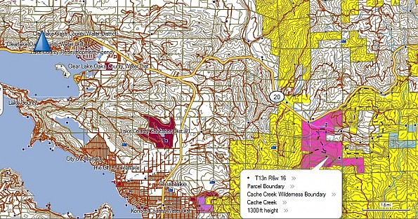
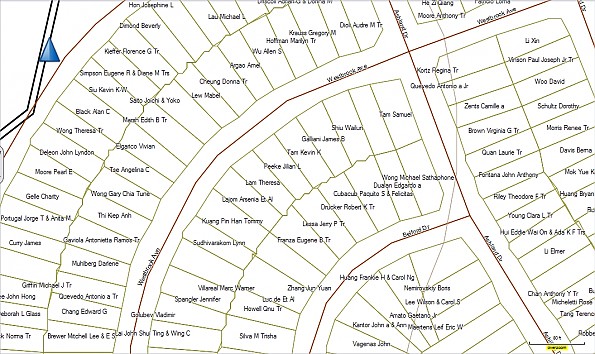
Let me also throw out a plug for "Hunting GPS Maps". (huntinggpsmaps.com). These guys are the "Cats Meow," the "Cherry on the sundae," the "Bomb"!! They make exceptional 1:24K PLAT maps that work on Garmin GPS devices. These maps will differentiate public lands, from private lands, from state lands, from National Parks, etc... On top of that, they will also include the land/property owners name. This is absolutely invaluable to a hunter, as getting caught on private land incurs a hefty fine!
If you purchase a PLAT map from these guys (which you should), make sure you get the downloadable version. (You can choose between downloadable, or a micro SD card). The reason is if you download the program, you can also use it on your PC or laptop. This is absolutely cool, as you can plan an entire trip on your laptop, mark your route, then send it to your GPS device. So when you go hiking or camping, it will tell you what route to take. (Your pre-planned route). Scha-weet! Below I will attach a few screen-captured maps from my PC. One will have different colored areas. These colors define whether it is private land, or BLM land, etc... The second picture is a screenshot of my partners neighborhood. Notice how it has the home owners names on it. Too cool.
Bottom line, great device. Two hawg tusks up!
Source: bought it new
Price Paid: I cannot remember...but I got it on sale.
Your Review
Where to Buy
You May Like
Specs
| not included | |||
|---|---|---|---|
| Price |
MSRP: $329.99 Historic Range: $183.83-$399.99 |
||
| Weight |
6.8 oz / 192.7 g with batteries |
||
| Dimensions |
2.3 in x 4.5 in x 1.4 in / 5.8 cm x 11.4 cm x 3.5 cm |
||
| Display size |
1.53 in x 2.55 in / 3.8 cm x 6.3 cm, 3 in diag / 7.6 cm |
||
| Display resolution |
240 x 400 pixels |
||
| Display type |
transflective color TFT touchscreen |
||
| Battery | 2 AA batteries | NiMH or Lithium recommended | |
| Battery life |
16 hours |
||
| Waterproof |
yes (IPX7) |
||
| Floats |
no |
||
| High-sensitivity receiver |
yes |
||
| Interface |
high-speed USB and NMEA 0183 compatible |
||