Maps
Top Picks
How we choose: The best maps highlighted here were selected based on 34 reviews of 21 products. Our top picks are those that are readily-available in the United States and have received the highest overall ratings from reviewers.
How we test: Trailspace is powered entirely by our community of readers. The reviews posted here reflect the real-world experiences of outdoor enthusiasts just like you.
If you've used a map that you think should be listed here, please share your experience.
Disclosure: Trailspace never accepts payment for gear reviews, product placement, or editorial coverage. When you buy through affiliate links on our site, Trailspace may earn a small commission, which helps cover the costs of running the site.
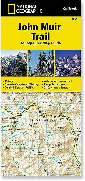
National Geographic John Muir Trail Topographic Map Guide
 Reviewed
by Bill S
Reviewed
by Bill S 
If you are contemplating thru-hiking the John Muir Trail (or any section of it), this John Muir Trail Topographic Map Guide does an excellent job of gathering all the needed information for planning, plus having detailed maps of the entire trail and surrounding terrain.
Reasons to Buy
- Detailed map guide to the John Muir Trail
- Small size (fits in pocket of shell jacket)
- Lightweight compared to other options
- Waterproof and tear resistant
- Accurate mileages to waypoints along the trail
- Includes resupply points with shipping info
- Includes trail profiles
Reasons to Avoid
- Information on permit procedure is somewhat sparse (need to go online to get details)
- Details are tiny, requiring good eyes or better glasses for us old geezers
- Grid is UTM/MGRS, so the Mercator flattening produces some distortion that lat/lon would reduce
Comparison of size of National Geographic Yosemite map with the John Muir Trail Topographic Map Guide (USGS 1:250,000 map in background) Background: I have to confess up front that, despite having hiked and climbed on all seven continents, including fairly extended expeditions (both time and distance), and having lived in California for a total of roughly 50 years (minus short sojourns in Massachusetts and Mississippi), I have not thru-hiked the entire length of the John Muir Trail, although I have hiked major portions.
Read more: National Geographic John Muir Trail Topographic Map Guide review (1)
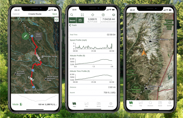
Gaia GPS Hiking, Offroad Maps App
 Featured review
by Inga Aksamit
Featured review
by Inga Aksamit
The main takeaway for me was that planning a route was significantly faster and more intuitive than any other mapping app I’ve used. The app does all the things we’ve come to expect from mapping apps, including pinning waypoints, creating routes, and tracking hikes, but offers many features that others don’t, including the national parks maps from National Geographic and cell phone coverage maps. The interface is clean and easy to understand and the maps are sharp without clutter.
Reasons to Buy
- Clear and legible maps
- Multiple map layers to choose from
- National Geographic National Parks maps
- Ease in route planning
Reasons to Avoid
- It costs money for the best features
Gaia GPS is a map application that allows you to plan routes, navigate on the trail, record waypoints and tracking. With a paid subscription, you can get access to different maps and map layers that can be downloaded for offline use. It can be used with mobile devices (Apple or Android) or the Gaia GPS website. Author at the start of the Glacier Point hike in Yosemite By now, many people are familiar with the basics about GPS apps, but in case this is new to you, your smart phone has powerful navigating capabilities when the built-in GPS function is used with a navigation application such as Gaia GPS.
Read more: Gaia GPS Hiking, Offroad Maps App reviews (3)
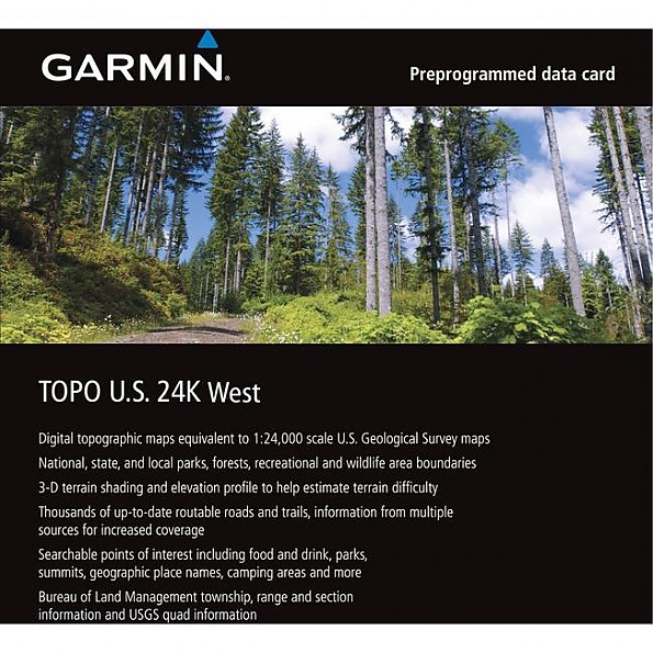
Garmin Topo US 24K West
![]() Reviewed
by Steverod
Reviewed
by Steverod 
This is a set of maps for Garmin GPS units that's also usable with Garmin's (free) BaseCamp trip planning software (BaseCamp runs on both Mac and Windows). If you don't have a Garmin GPS, you are NOT interested in this software (I suppose you could use it just for trip planning on your computer, but it would be awfully expensive relative to the competition). These maps offer detail "similar to" a USGS 24K (7.5 minute) map for your GPS. My review summary is: I'm glad I got these maps; they have been very useful and fun for me, because I do advance trip planning on my computer, because I use my hiking GPS for driving as well, and because I really only go hiking/driving to remote trailheads in California.
Read more: Garmin Topo US 24K West review (1)
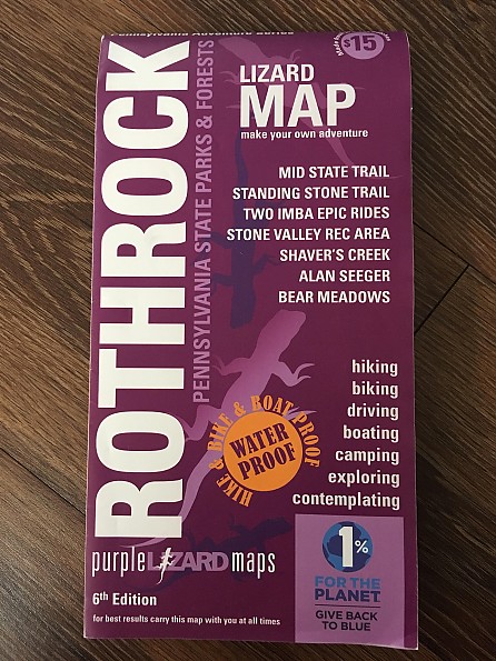
Purple Lizard Maps Rothrock State Forest Trail Map
 Featured review
by KiwiKlimber
Featured review
by KiwiKlimber 
A hardy map that can withstand punishment and inspire exploration. The Purple Lizard Rothrock State Forest map thoroughly covers the forest, as well as areas north and south of the forest boundaries. Best for folks living in or looking to explore Central Pennsylvania, or for people who really like maps, I suppose.
Reasons to Buy
- Waterproof
- Highly durable
- Easy to read
- Highlights like-minded local businesses
- The company’s signature hidden purple lizards scattered throughout the map (signifies a cool spot, but doesn’t tell you what it is...makes for a fun surprise).
- Additional trip-planning resources on company's website
- 1% For the Planet member
Reasons to Avoid
- Pretty big and bulky
- Area business ads take away from the map
Usage:I own other Purple Lizard maps, but this one gets the most use, as the Rothrock State Forest and surrounding areas are pretty easy to explore via hiking, camping, biking, hunting, and fishing. The double-sided map covers the entirety of the mountainous Rothrock State Forest and its many trails, and also includes: Five nearby natural areas (Bear Meadows, Detweiler Run, Alan Seeger, Rocky Ridge, and Little Juniata) Two state parks (Whipple Dam and Greenwood Furnace) PA State Game Lands, including their specific ID number (very helpful).
Read more: Purple Lizard Maps Rothrock State Forest Trail Map reviews (2)
CritterMap Backcountry Navigator for Android
 Featured review
by OldCodgerMe
Featured review
by OldCodgerMe
Topo map GPS navigation program for Android phones. Download maps in advance from various map sources, or custom source and use them in realtime on your phone while you hike. Add points-of-interest, waypoints. Log your actual routes, save and share them. Excellent product with a somewhat non-intuitive user interface, recommended for backcountry hikers.
Reasons to Buy
- Full function navigation program without buying a separate handheld GPS unit
- High-resolution maps available (especially AccuTerra)
- Add waypoints as you hike, add notes, comments
- Works on a wide variety of Android phones
- Active developer who responds quickly to issues and continually evolves the capabilities
- Fast satellite location, satellite view
Reasons to Avoid
- No version for Apple IOS
- If used continually, will quickly suck down phone battery
- Many capabilities are buried in the menu structure
- Map management is somewhat kludgy
The Backcountry Navigator program for Android has been a really useful tool for me, which is why I thought I'd share my experience with it. It is by no means perfect, nor does it have as much raw capability as the best dedicated Nav devices. But for the dayhiker, the dogwalker, and the casual weekend backpacker, it might be exactly what you need. The Backcountry Navigator program is cheap, and effective. It is available through the Google Play store, or at the Amazon app store. There's a free trial version, but the full version is about $10 at https://play.google.com/store/search?q=backcountry+navigator Various map sources are available free, and there are also premium map sources available for an extra fee. I've been using the...
Read more: CritterMap Backcountry Navigator for Android reviews (2)
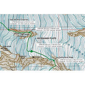
Carin Mountain Company Mount Rainier Guide Reference Map
 Reviewed
by FromSagetoSnow
Reviewed
by FromSagetoSnow
The best, most feature-packed map I have used yet.
Reasons to Buy
- Durable, rubbery material, rip-proof
- Zoomed in to show details
- GPS coordinates
- Compas bearings
- Shows most common routes
Reasons to Avoid
- I didn't find it sooner
- Doesn't cover Gib Ledges or Fuhrere Finger routes
I thought maybe I wouldn't review this because I used it in optimal weather and not an epic but I want to spread the word about it to potential Rainier climbers. This map shows the three most common routes on Rainier (DC, Emmonds,Kautz) and gives compass bearings to recognizable landmarks (magnetic and declination) to assist you in navigating home in a whiteout. It also provides GPS coordinates in two different formats for finding the same. The map also shows close ups of the hike to Muir, Hazard and Schumann as well as the sections from each camp to summit. The general routes are all marked on the map. It is obvious that a lot of thought went into this map.
Read more: Carin Mountain Company Mount Rainier Guide Reference Map review (1)
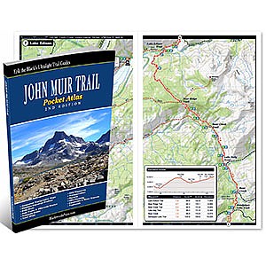
Blackwoods Press John Muir Trail Pocket Atlas
 Reviewed
by Mike Mineart
Reviewed
by Mike Mineart
The is a great, extremely light, pocket atlas/set of maps for doing the John Muir Trail.
Reasons to Buy
- Complete set of maps for the JMT
- Has camp location and water source info
- Very light
Reasons to Avoid
- None
I picked up Erik the Black's Ultralight trail guide for the JMT last summer for use on a couple of section hikes I was doing. The trail guide is only about 2.5 oz, very thin, and about the same dimensions as most paperback books available now days. Each of the maps in the guide include an elevation profile, information on camp and water locations along with a variety of other information useful during your hike of the JMT. This really is a great set of maps and a competent hiker with average navigation skills will find this is all they need for the JMT.
Read more: Blackwoods Press John Muir Trail Pocket Atlas review (1)
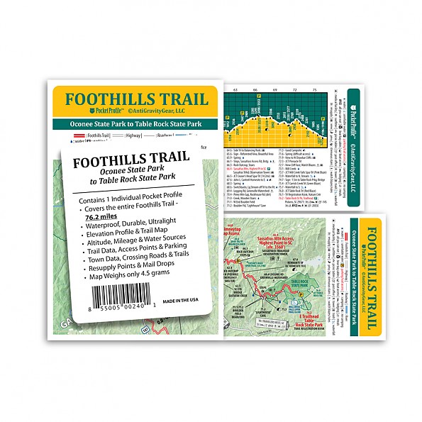
AntiGravityGear Foothills Trail Pocket Profile
 Reviewed
by Bentbrook
Reviewed
by Bentbrook
For day hikers and thru-hikers who want a quick reference guide to a trail that doesn’t skimp on information, doesn't require electricity, and which only adds negligible weight (.18 oz/5 g), AntiGravityGear’s Pocket Profile is an aptly named resource worth both the weight and the cost (USD $3.95)!
Reasons to Buy
- lightweight
- lots of essential trail information
- easy to read with a little practice
- very inexpensive
- updated annually
Reasons to Avoid
- trail information may be out of date
AntiGravityGear produces a number of useful little publications called Pocket Profiles. Among their Pocket Profile titles are releases for the Appalachian Trail (22 different sections/profiles), the Benton MacKaye Trail, the Art Loeb Trail, the John Muir Trail, and the Foothills Trail. The last is the one I purchased and used during my thru-hike of the Foothills Trail in June of 2019. A Pocket Profile contains a plethora of information. In the case of the Foothills Trail Pocket Profile, AntiGravityGear claims to provide the following: “The entire 76.2 miles of the Foothills Trail at a glance! Weighing in at just 4 grams, this water-proof, durable map features a Foothills Trail map on one side and an elevation profile with altitudes and...
Read more: AntiGravityGear Foothills Trail Pocket Profile review (1)
Appalachian Mountain Club White Mountain Guide Online
 Reviewed
by Dave MacLeay
Reviewed
by Dave MacLeay
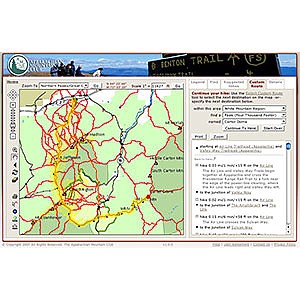
If you’ve done much hiking in the Northeast, you’re probably familiar with the Appalachian Mountain Club’s guidebooks. The venerable White Mountain Guide – continuously published for 100 years and now in its 28th edition – is the standard reference for hiking in New Hampshire’s high peaks. For the centennial edition, the AMC has added an online companion guide that pulls from, and even improves upon, the original. The centerpiece of the White Mountain Guide Online is an interactive trail map that allows users to explore more than 500 trails in the White Mountain National Forest and nearby areas.
The White Mountain Guide Online interface. Using the old paper guide, planning a trip that links more than one or two trails often requires flipping back and forth between several different pages to keep track of mileage, trail descriptions, etc. With the online guide, you can create a route by selecting trail segments from the map. Relevant trail descriptions are then displayed in the proper order and with mileage, elevation gain/loss, and “book time” automatically calculated. Points of interest and trail junctions are all clearly laid out.
Read more: Appalachian Mountain Club White Mountain Guide Online review (1)
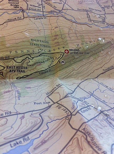
Purple Lizard Maps Bald Eagle State Forest Map
Reviewed
by KiwiKlimber
A map that covers a somewhat overlooked, underexplored, and fairly large area in Central Pennsylvania (Bald Eagle State Forest). The map, in its typical Purple Lizard fashion, is super-durable and could serve as an emergency umbrella if necessary (only half joking...it is waterproof though). Best for those living in or exploring Central Pennsylvania or for map-junkies.
Reasons to Buy
- Waterproof
- Highly durable
- Covers an area that is overlooked by many
- Easy to read
- Highlights like-minded local businesses
- The company’s signature hidden purple lizards scattered throughout the map (signifies a cool spot, but doesn’t tell you what it is...makes for a fun surprise).
- Additional trip-planning resources on the company's website
- 1% For the Planet member
Reasons to Avoid
- Pretty big and bulky
- Area business ads take away from the map
Usage:Admittedly, like many in Central Pennsylvania, I’ve explored many of the trails covered by the popular Purple Lizard Rothrock State Forest map more, but this map has almost single-handedly led me to explore the often-overlooked Bald Eagle State Forest. I think a good map can draw a reader to the locale it highlights, and that’s exactly what has happened several times with this map. Map Material:The map is made of a thin plastic-like material that folds well. It is not paper coated in plastic, but rather fully plastic itself.
Read more: Purple Lizard Maps Bald Eagle State Forest Map review (1)
Other Types of Books and Maps
Find more books and maps reviewed in these related categories:
Guidebooks
Outdoor Skills Books
all Books and Maps
Review Your Outdoor Gear
If you've found this site helpful — or if we've missed something important — please consider paying it forward by some of your favorite outdoor gear.
Why? From professional gearheads to outdoor novices, everyone has an important point of view to contribute. will support the outdoor community and help others find the best gear.
Trailspace reviewers are outdoor enthusiasts like you: hikers, climbers, paddlers, backcountry skiers, and trail runners who share our experiences with the gear and clothing we rely on to get outside. Learn more about Trailspace