US National Parks GeoFlyer 3D Maps
![]() Reviewed by
Reviewed by
Giulio Giannardi
+12
 October 24, 2013
Great App for hiking US National Parks in 3D! Ideal for hikers, climbers, bikers, backpackers and for all they want to practice outdoor activities in US National Parks.
Excellent 3D navigation and views, very high quality and useful topo maps with tons of paths, trails and info, always keep updated! All the usual stuff like GPS, tracking, routing, stats, info, sharing... Works also offline!
Pros
- Excellent 3D views and navigation of the parks
- High quality topo maps in 3D
- Great tracking and routing, also offline!
- Cool features like "flying over" the park
Cons
- Coverage limited to US National Parks
GeoFlyer 3D Maps US National Parks review - iPhone App
Hi guys! Wanna let you know about this new app for hiking, I reviewed this summer!
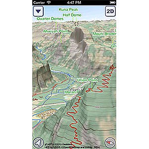
The App is a 3D navigation app for US National Parks. It's ideal for all hikers, backpackers, outdoor lovers and all they want a great guide for their trips and a great topo map always updated with the power of 3D visualization. As far as I know, at the moment there is no other app with so hi-quality images in 3D.
Since I live in Italy, I reviewed a beta version with a specific map for the Alps, needed for my hikes.
I used an iPhone 4s, always in offline mode, since there was no data connection where I was.
The first cool stuff is that the app works like a charm in offline mode, so that you don't have problems in remote places or canyons, also, doesn't drain battery: after 12 hours of hiking/climbing, with elevations between 6500/10500 ft, the battery was around 30%, not bad considering the GPS was always ON for tracking.
The quality of images and the 3D visualization is astonishing: never seen something like that before. A great pro is that the 3D works also for the topo map, so you can see your height and topo info clearly.
Tracking is good and not battery draining, but I was impressed by routing: it uses a specific database with all the paths and trails available, so you can plan your routes in the wild! Not comparable with all the other routing services like Google Maps and similar that stop where the street ends.
The app is available on the AppStore for 0.99$. The price quite fair, comparing to the quality. The Yosemite map is included and you can purchase the other maps for 0.99 each or the entire map set for 4.99$.
If you buy the entire set, you'll be able to download the new parks maps, since the map coverage is growing fast.
Just to give you some more hints, check it out on the AppStore, YouTube for more videos or the FB fan page.
Let me know, Giulio
Source: tested or reviewed it for the manufacturer (Keep it! Sure!)