Outdoor Apps
Top Picks
How we choose: The best outdoor apps highlighted here were selected based on 13 reviews of 10 products. Our top picks are those that are readily-available in the United States and have received the highest overall ratings from reviewers.
How we test: Trailspace is powered entirely by our community of readers. The reviews posted here reflect the real-world experiences of outdoor enthusiasts just like you.
If you've used a outdoor app that you think should be listed here, please share your experience.
Disclosure: Trailspace never accepts payment for gear reviews, product placement, or editorial coverage. When you buy through affiliate links on our site, Trailspace may earn a small commission, which helps cover the costs of running the site.
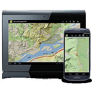
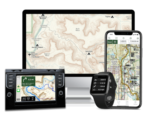
CritterMap Backcountry Navigator for Android
 Featured review
by OldCodgerMe
Featured review
by OldCodgerMe 
Topo map GPS navigation program for Android phones. Download maps in advance from various map sources, or custom source and use them in realtime on your phone while you hike. Add points-of-interest, waypoints. Log your actual routes, save and share them. Excellent product with a somewhat non-intuitive user interface, recommended for backcountry hikers.
Reasons to Buy
- Full function navigation program without buying a separate handheld GPS unit
- High-resolution maps available (especially AccuTerra)
- Add waypoints as you hike, add notes, comments
- Works on a wide variety of Android phones
- Active developer who responds quickly to issues and continually evolves the capabilities
- Fast satellite location, satellite view
Reasons to Avoid
- No version for Apple IOS
- If used continually, will quickly suck down phone battery
- Many capabilities are buried in the menu structure
- Map management is somewhat kludgy
The Backcountry Navigator program for Android has been a really useful tool for me, which is why I thought I'd share my experience with it. It is by no means perfect, nor does it have as much raw capability as the best dedicated Nav devices. But for the dayhiker, the dogwalker, and the casual weekend backpacker, it might be exactly what you need. The Backcountry Navigator program is cheap, and effective. It is available through the Google Play store, or at the Amazon app store. There's a free trial version, but the full version is about $10 at https://play.google.com/store/search?q=backcountry+navigator Various map sources are available free, and there are also premium map sources available for an extra fee. I've been using the...
Read more: CritterMap Backcountry Navigator for Android reviews (2)
Survival Guide by Max Soderstrom

 Reviewed
by Ben Rivers
Reviewed
by Ben Rivers 
This is an excellent educational app on survival skills. I keep this app installed on my iPhone just in case I find myself in a situation where I don't know what to do. It is a must have for those not familiar with the outdoors or just beginning to adventure outdoors and is good for experts as well.
Reasons to Buy
- FREE
- Thorough
- Pictures
Reasons to Avoid
- Ads
This app is an absolute must have if you like being in the outdoors at all. Especially if you are going to venture away from civilization because you never know what might happen. The Survival Guide app is thorough in explaining basic survival skills that can be very beneficial to someone in a life threatening situation. I love that there are apps with this kind of information. Since I will have my iPhone with me on most any outdoor trip I go on, I will always have this information with me, without the extra bulk of a book.
Read more: Survival Guide by Max Soderstrom review (1)
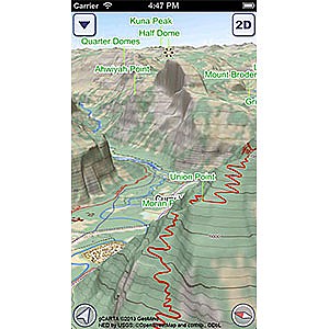
US National Parks GeoFlyer 3D Maps
![]() Reviewed
by Giulio Giannardi
Reviewed
by Giulio Giannardi
Great App for hiking US National Parks in 3D! Ideal for hikers, climbers, bikers, backpackers and for all they want to practice outdoor activities in US National Parks. Excellent 3D navigation and views, very high quality and useful topo maps with tons of paths, trails and info, always keep updated! All the usual stuff like GPS, tracking, routing, stats, info, sharing... Works also offline!
Reasons to Buy
- Excellent 3D views and navigation of the parks
- High quality topo maps in 3D
- Great tracking and routing, also offline!
- Cool features like "flying over" the park
Reasons to Avoid
- Coverage limited to US National Parks
GeoFlyer 3D Maps US National Parks review - iPhone App Hi guys! Wanna let you know about this new app for hiking, I reviewed this summer! The App is a 3D navigation app for US National Parks. It's ideal for all hikers, backpackers, outdoor lovers and all they want a great guide for their trips and a great topo map always updated with the power of 3D visualization. As far as I know, at the moment there is no other app with so hi-quality images in 3D. Since I live in Italy, I reviewed a beta version with a specific map for the Alps, needed for my hikes.
Read more: US National Parks GeoFlyer 3D Maps review (1)
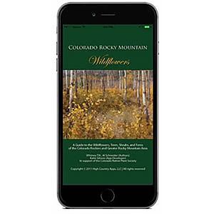
High Country Apps Colorado Rocky Mountain Wildflowers
 Reviewed
by BigRed
Reviewed
by BigRed
A well thought-out app that pros and beginners alike can use to identify most of the hundreds of species of wildflowers, trees, and shrubs in the central Rocky Mountains and nearby ranges.
Reasons to Buy
- Nearly comprehensive coverage of species in the target region
- Searchable by common and scientific species and family names
- Random access searching by a broad range of characteristics
- Multiple color photos of each species
- Text descriptions, range maps, and additional info
- Price
Reasons to Avoid
- Could combine family and characteristics searches
- Text descriptions are rather technical for the layman
As a card-carrying botanist (my BSc is in botany) one of my main ways of relating to the natural world is by paying attention to the local flora, wherever and whenever I am. Depending on how far the where is from familiar botanical territory, whether or not the when is at a time when plants are in bloom, and just how darn many plants there are out there to ID, this can be a more or less challenging task. High summer in the Rocky Mountains, with its vibrant show of forest, meadow, and the alpine wildflowers, is a prime time and place for me to practice that craft.
Read more: High Country Apps Colorado Rocky Mountain Wildflowers review (1)
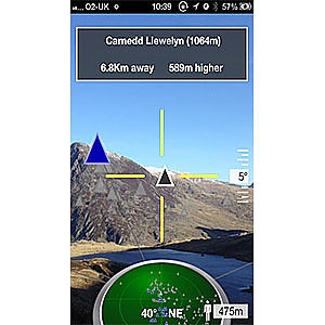
Peak Scanner
![]() Reviewed
by Gary Waite
Reviewed
by Gary Waite
Amazing hiking app. When I'm out hiking I find it difficult to figure out the names of the mountain peaks I can see using a map. Peak Scanner is a mobile app that is really simple to use. All I have to do is start up the app and literally point my phone at the mountain I'm interesting and it tells me all about it. Including how far away it is, its height (especially how much higher it is than where I am now) etc. Really simple to use. Amazing.
Reasons to Buy
- Simple to use — just point!
- Inexpensive
- Seems to work worldwide
Reasons to Avoid
- Need a phone with you
Peak Scanner is an app available for the iPhone 4 and above that automatically tells you information about any mountain peak in the distance if you simply point your phone at it. It uses a thing called Augmented Reality, which means (I think!) it overlays extra information on top of the camera view you see on the screen. There are no buttons to press. It just does it's job and very effectively too. And it's very cheap to buy. There is an iPhone version and also one for Android I believe. There are other apps I've downloaded of this type, but they've all been pretty rubbish when there are lots of mountains around - too much cluttered information on the screen.
Read more: Peak Scanner review (1)
Gaia GPS Hiking, Offroad Maps App
 Featured review
by Inga Aksamit
Featured review
by Inga Aksamit
The main takeaway for me was that planning a route was significantly faster and more intuitive than any other mapping app I’ve used. The app does all the things we’ve come to expect from mapping apps, including pinning waypoints, creating routes, and tracking hikes, but offers many features that others don’t, including the national parks maps from National Geographic and cell phone coverage maps. The interface is clean and easy to understand and the maps are sharp without clutter.
Reasons to Buy
- Clear and legible maps
- Multiple map layers to choose from
- National Geographic National Parks maps
- Ease in route planning
Reasons to Avoid
- It costs money for the best features
Gaia GPS is a map application that allows you to plan routes, navigate on the trail, record waypoints and tracking. With a paid subscription, you can get access to different maps and map layers that can be downloaded for offline use. It can be used with mobile devices (Apple or Android) or the Gaia GPS website. Author at the start of the Glacier Point hike in Yosemite By now, many people are familiar with the basics about GPS apps, but in case this is new to you, your smart phone has powerful navigating capabilities when the built-in GPS function is used with a navigation application such as Gaia GPS.
Read more: Gaia GPS Hiking, Offroad Maps App reviews (3)
Knots Guide App
 Reviewed
by FromSagetoSnow
Reviewed
by FromSagetoSnow 
When you don't have a lot to do or want to learn a new knot, use this app.
Reasons to Buy
- Easy to navigate
- Useful AND interesting obscure knots
- Some step-by-step instructions
- Knots organized by type
- History of many knots included
- Works when you have ZERO bars
- FREE!!!!!
Reasons to Avoid
- Some pictures are better than others
- A few knots I think of are not listed
A great TS reviewer just reviewed a set of cards which teach various knots and I thought, "What about that knot app on our Galaxy phone that we use Precious? Think anyone would like it?" So here we are. I downloaded this app mainly as something to mess with while I traveled since I usually have some perlon cord around to play with. I was tired of the other games on my phone. Besides, who couldn't do with some more knot practice right? Ok, so I'm a nerd. This app categorizes knots into Bend knots, Binding knots, Climbing knots, Decorative knots, Fishing knots, hitch knots, Looping knots, Running knots, Stopper knots and Whipping knots.
Read more: Knots Guide App review (1)
More Reviews of Outdoor Apps
Trailspace reviewers have shared 13 reviews of 10 different outdoor apps.
or add yours
Other Types of Electronics
Find more electronics reviewed in these related categories:
Altimeters
Beacons
Cameras
+9 more types
Review Your Outdoor Gear
If you've found this site helpful — or if we've missed something important — please consider paying it forward by some of your favorite outdoor gear.
Why? From professional gearheads to outdoor novices, everyone has an important point of view to contribute. will support the outdoor community and help others find the best gear.
Trailspace reviewers are outdoor enthusiasts like you: hikers, climbers, paddlers, backcountry skiers, and trail runners who share our experiences with the gear and clothing we rely on to get outside. Learn more about Trailspace