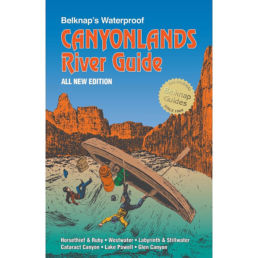
Westwater Books Belknap's Waterproof Canyonlands River Guide


 Reviewed by
BigRed
TOP 10 REVIEWER
REVIEW CORPS
+10,775
 April 2, 2019 (original Mar 30, 2019)
A classy, cargo pocket-sized, waterproof guide to over 350 miles of the Green and Colorado Rivers through and above Canyonlands National Park, with detailed maps, illustrations, and text on the region’s colorful geology and history. Works well as a stand-alone guide for river trips.
Pros
- Nicely rendered maps with plenty of detail on the river and immediate surroundings
- Overview of regional geology and river history
- Maps augmented with photos, notes, and quotes from explorers
Cons
- No info on water sources
- No mention of Native American history
- Lake Powell map is an afterthought
In the winter of 2018, during our year-long residence in Tuscson, my wife and I decided to splurge on a 6-day guided raft/dory trip on the Colorado River from near Moab, Utah, down through Cataract Canyon in Canyonlands National Park to the uppermost reach of Lake Powell. The rafting company, OARS, threw in a copy of this Belknap River guide for the same price as you’d buy it anywhere else, and sent it on ahead to give us something to read or maybe just drool on—good thing it’s waterproof.
I ended up doing a fair bit of the trip in an inflatable self-bailing kayak, which lets water into its bilge just as well as it lets it out, so that you paddle along with your butt pickling in a couple inches of river water. I kept this book tucked by my thigh much of the time, pulling it out to check our position and read up the geology and history of the river and canyon. Good thing it’s waterproof!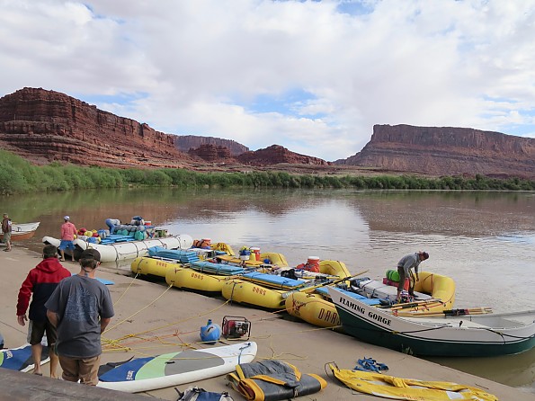
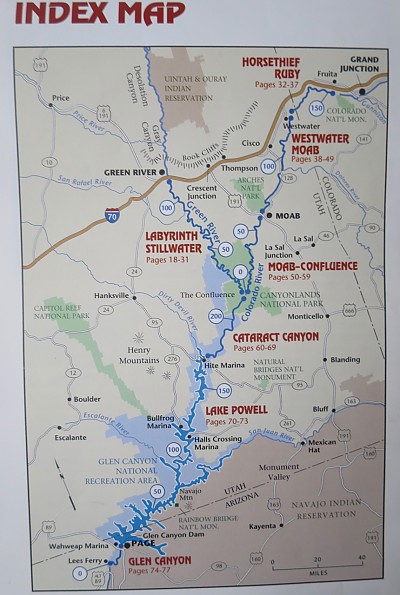
The book is sized to fit in a cargo pants pocket (8.5 x 5.5") and printed on heavy-duty waterproof paper. If it gets soaked it can be dried by separating the pages as they dry to keep them from sticking together. Its 80 pages plus cover weigh in at 7 ounces. It gives detailed, 1.5 inch-per-mile coverage of the 120 miles of the Green River from the Utah town of the same name down to its confluence with the Colorado River, and about 150 miles of the Colorado River from Loma, Colorado down past the same confluence, and through Cataract Canyon.
For good measure it includes a large scale (about 1.5 inches for 10 miles) map of 170-mile Lake Powell with all its bays and another detailed 15 miles of the river from Glen Canyon Dam down to Lee’s Ferry, where you’d have to move on to Belknap’s Grand Canyon guide to get similar coverage of Marble Canyon and The Big Ditch.
A pair of introductory chapters introduce the geology (10 pages, contributed by R.J. Johnson) and history (3 pages) of the river. The geology section tries to start readers from scratch, with sidebar definitions of basic rock types and a few other terms, but it would probably help to have some idea of some of the general principles, including the geologic time scale, before diving in. I didn’t see too many of my fellow travelers on the raft trip paying much attention to the geology, but I sure did.
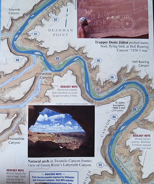
Half of the 10 pages are taken up by a pair of colorful wedding-cake diagrams of the rock layers in Canyonlands and along the Colorado above Moab, along with a 3-D cutaway panorama of Canyonlands above the confluence. Combined with the geology notes on the map, which helpfully point out wherever you encounter a new layer, these do a pretty good job of helping boaters figure out which rock layer is drifting by on any given stretch of river. Two pages highlight special landforms and mining resources of Canyonlands.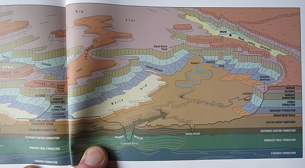
The brief history section is basically all about White Men, from early river runners and Mormons to miners and damn dam builders. The locations and details of the action are filled in by photos and notes on the maps.
In keeping with the general north to south orientation of the rivers, the pages in this guidebook turn vertically so that you can follow the twists and turns on your route from top to bottom on the nicely rendered maps. Topography is shown in with 20-foot contour intervals and emphasized with color and shading: blue river with white Vs for rapids, brown-stippled sandbars, green bottomlands textured where there is shrub cover, tan canyon walls, and off-white for the canyon rim and uplands. River miles above the confluence are clearly marked for the upper stretches and above Lee’s Ferry for the Colorado River below the confluence.
The focus is on the river; trails and jeep roads in and above the river corridor are shown, but they often disappear off the edge or under photos and text. Much of the space outside the river corridor, including the insides of the river bends, is filled in with notes and photos on the local geology, landscape, pre- and recorded history, and quotes from John Wesley Powell or other personalities. Designated campsites on some stretches are shown, perhaps ironically, as teepees. Phone numbers and web site URLs of management agencies and a few other sources of info are given in the introductory text on each river section; if you’re looking for an outfitter you’re on your own.
All this adds up to a lot of information and detail that serves to enrich the river experience for anyone that wants to get a little more out of it than just thrills and awesome scenery.
One thing I might miss is any indication of where I might find good water, because the silty river water is unfilterable and probably rather strongly flavored. Big raft groups can carry enough drinking and cooking water, but those of us in smaller craft on longer trips might end up powerful thirsty. My hiking experience in Paria Canyon, the Grand Canyon, and upland parts of Canyonlands would suggest there must be the occasional reliable spring, even if it is tucked away up in one of the side canyons.
This and other Belknap guides could serve well as the main or only source of detailed info about these river routes, but they could still be augmented with topo maps. While it might get you down through Lake Powell, you’ll want something much more detailed if you’re going to explore all those drowned canyons.
Overall, I’d call this a classy piece of work. The Belknap river guides have been a specialty product of the eponymous family since southwestern photographer and all-around good guy Bill Belknap put the first Grand Canyon guide together in 1969. Now Bill and three of the next Belknap generation all appear in the credits, with thanks and acknowledgements given to a couple dozen other river personalities and organizations. I don’t know what the first guides looked like, but the Belknaps have had 50 years to improve on them, and I’d say they’ve done a darn good job. Right up to the waterproof paper.
Background
Used it on a 6-day raft/dory trip through Cataract Canyon.
Source: bought it new
Price Paid: $19.95