 by Alicia MacLeay
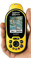 DeLorme’s new Earthmate GPS PN-20 is the only handheld GPS that can display aerial imagery, DeLorme topo maps, and USGS 7.5-minute quad maps. The waterproof GPS PN-20 holds up to 10 tracks, 1,000 user-defined waypoints, and 50 routes. The aerial imagery option would have been seriously useful on my last off-trail backpacking trip. Delorme gives you a certificate to download $100 worth (400 sq. km) of aerial imagery with the PN-20, just enough to get you started. Alas for Mac users, the Topo USA 6.0 mapping software only works with Microsoft Windows Vista, Windows 2000, and XP. (2.43" x 5.25" x 1.5", 5.12 oz, $399.95, available now)
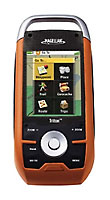 For the first time National Geographic maps will be available on a handheld GPS with Magellan’s Triton series. Users will be able to layer Magellan’s topographic maps and National Geographic TOPO!’s five layers of maps (28 titles cover all 50 states) on one device. The six GPS units in the series (Triton 2000, 1500, 500, 400, 300, and 200) are water submersible and offer full-color, touch-screen controls, and an easier to use interface. Units in the series include a range of features, depending on the model, including the ability to record and attach audio to waypoint files, a built-in 2MB pixel camera, digital compass, barometer, and built-in LED flashlight (Triton 2000: $499 - Triton 200: $129, expected availability September).


